Skip to content
Palisades Tahoe Logo Palisades Tahoe Logo Palisades Tahoe Logo
Explore
Main Menu
  • Explore Palisades Tahoe
  • Base to Base Gondola
  • Our New Name
  • Explore Legendary Lifts
  • Palisades Tahoe Blog
  • About Lake Tahoe
  • About Us
Plan Your Visit
Main Menu
  • Tickets & Passes
  • Lodging
  • Lessons & Guides
  • Deals & Packages
  • Rentals & Demos
  • Travel Here
  • Getting Around
Mountain Information
Main Menu
  • Snow and Weather
  • Lift and Grooming Status
  • Webcams
  • Hours of Operation
  • Trail Maps
  • Parking & Road Conditions
  • Snowfall Tracker
Events & Activities
Main Menu
  • Events Calendar
  • Activities
  • Dining & Apres
  • Shopping
  • Things To Do In Lake Tahoe
  • Groups, Meetings & Weddings
  • Ski & Snowboard Teams
IKON PASS HOLDER LODGING DISCOUNT

Ikon Pass holders save up to 20% on slopeside lodging at The Village at Palisades Tahoe.

SLOPESIDE LODGING
Icon / FlashCreated with Sketch.
View All Offers
  • Weather

Weak System Thu Night, Mild Weekend

  • Dec 22, 2022
  • 8:09 am

Thursday:

For Thursday we are expecting mostly cloudy skies as a weak system approaches. Highs in the 30s on the upper mountain 40s at the base. Ridgetop winds increasing from the west with gusts up to 30+ mph up top by afternoon.

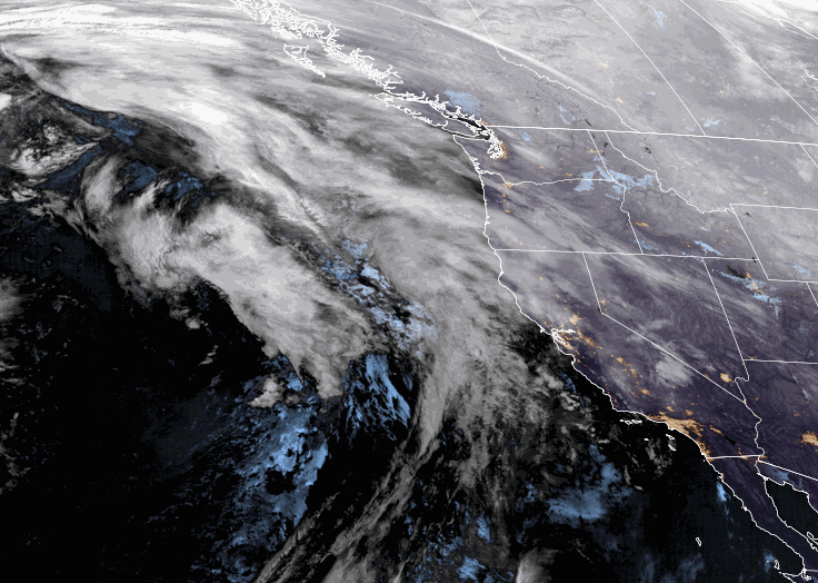
Thursday Night Showers:

Thursday night a weak system will brush the northern Sierra with a few showers. Snow levels could be above 7500 ft. with some rain showers at the base and maybe a dusting to an inch of wet snow on the upper mountain by Friday morning.

Friday thru Monday:

Strong high-pressure builds in over CA for Christmas weekend. Partly sunny Friday and Monday as one system departs and the next moves closer. Saturday and Sunday we should see mostly sunny skies and lighter winds.

Milder temperatures starting Friday. Highs into the 40s Friday and then 50s at the base by Sunday. Overall a pretty nice weekend is expected for skiing and travel. Expect soft snow by midday each day.

Monday the clouds and winds increase ahead of a stronger storm. Ridgetop winds could increase from the southwest with gusts up to 50+ mph by Monday afternoon.

Tuesday – Wednesday Storm:

Starting the 27th through the end of December we are expecting a wetter pattern with a parade of storms. We could see up to 4 storms in 5-6 days through New Year’s weekend.

The first storm is expected to move in by Tuesday morning. This storm will bring strong winds with gusts up to 100+ mph up top likely for Tuesday. Then coming down some Wednesday but maybe not a lot with the next storm approaching. Heavy precipitation is expected Tuesday into Tuesday night and then lighter Wednesday and possibly ending by evening.

Snow levels could start up above 8500 ft. Tuesday morning which would be rain on most of the mountain. Then falling through the day and into Wednesday. Snow levels could be near 7000 ft. by Tuesday evening and near the base by Wednesday morning. 

We have a lot of fine-tuning to do as we get closer. We could see 2-3 ft. up top and maybe less than a foot at the base with the snow levels starting high with rain on the lower mountain and at the base. We’ll update the snow level and snowfall forecast daily.

Long-Range:

Each storm could be quite wet and windy. We could see snow levels start higher with each storm and then fall with each cold front. Strong winds with each could affect lift operations throughout the week and into New Year’s weekend.

We’ll continue to watch the trends as each storm gets closer. You’ll want to stay tuned to the forecast if you plan to be at the mountain or in the Sierra Tuesday through the New Year’s weekend.

The active pattern could continue through the first week of January.

BA

lake tahoe weather palisades tahoe weather forecast snowfall forecast
Bryan Allegretto
Bryan Allegretto

Share this article:

Recent Posts

  • Weather ·
  • February 8, 2023·

Tracking Light Snow for Friday Night

Wednesday – Thursday: Mostly sunny skies through Thursday. Highs into the 30s for the upper mountain and 40s at the…
Read more
  • Weather ·
  • February 7, 2023·

Weak System Possible Fri Night – Saturday

Tuesday – Thursday: Mostly sunny skies with a few clouds possible through Thursday as high pressure builds in over CA.…
Read more
  • Weather ·
  • February 6, 2023·

1-2 Feet of Fresh Snow

Snowfall Report: We definitely saw more than the 8 inches being reported by mountain ops fall on the mountain on…
Read more

Social

Instagram Twitter Facebook Youtube

Contact

   Email Us
   1.800.403.0206

Our Partners

U.S. Forest Service Logo
1960 Olympic Valley Road
Olympic Valley, CA 96146

©2022 Palisades Tahoe

Alterra Mountain Company
  • Privacy Policy
  • Terms of Service
  • Photo Upload Terms of Use
  • Accessibility
  • Do Not Sell My Personal Information
  • Privacy Policy
  • Terms of Service
  • Photo Upload Terms of Use
  • Accessibility
  • Do Not Sell My Personal Information