Skip to content
Palisades Tahoe Logo Palisades Tahoe Logo Palisades Tahoe Logo
Explore
Main Menu
  • Explore Palisades Tahoe
  • Base to Base Gondola
  • Our New Name
  • Explore Legendary Lifts
  • Palisades Tahoe Blog
  • About Lake Tahoe
  • About Us
Plan Your Visit
Main Menu
  • Tickets & Passes
  • Lodging
  • Lessons & Guides
  • Deals & Packages
  • Rentals & Demos
  • Travel Here
  • Getting Around
Mountain Information
Main Menu
  • Snow and Weather
  • Lift and Grooming Status
  • Webcams
  • Hours of Operation
  • Trail Maps
  • Parking & Road Conditions
  • Snowfall Tracker
Events & Activities
Main Menu
  • Events Calendar
  • Activities
  • Dining & Apres
  • Shopping
  • Things To Do In Lake Tahoe
  • Groups, Meetings & Weddings
  • Ski & Snowboard Teams
IKON PASS HOLDER LODGING DISCOUNT

Ikon Pass holders save up to 20% on slopeside lodging at The Village at Palisades Tahoe.

SLOPESIDE LODGING
Icon / FlashCreated with Sketch.
View All Offers
  • Weather

Weak System Possible Fri Night – Saturday

  • Feb 7, 2023
  • 8:29 am

Tuesday – Thursday:

Mostly sunny skies with a few clouds possible through Thursday as high pressure builds in over CA. Highs warming into the 30s for the upper mountain and 40s at the base. Lighter winds are expected through Thursday.

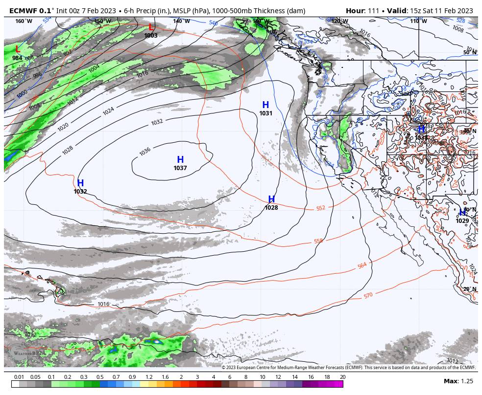
Friday Night – Saturday System:

We will see increasing winds ahead of the system on Friday with ridgetop gusts up to 50-60+ mph from the southwest, which could affect some upper mountain lifts. Increasing clouds as well through the afternoon. Highs are still in the 30s for the upper mountain and 40s at the base.

Snow showers could reach the Sierra between 4-10 PM Friday evening, and then possibly continue through Saturday into Saturday evening before clearing out. They should be fairly light and scattered over the 24-36 hour period. Snow levels may start near the base but should fall pretty quickly.

We could see gusty northeast winds set up for Saturday, with ridgetop gusts up to 50-60+ mph. That could affect some exposed upper mountain lifts again. Highs in the 30s. Here is my initial snowfall forecast for potential snowfall totals by Sunday morning.

  • 1-3 inches at the base.
  • 2-4 inches at mid-mountain elevations.
  • 3-5 inches up top.

We’ll continue to watch the trends and fine-tune the forecast over the next few days.

Sunday:

For Sunday we clear out with colder temperatures behind the storm. Partly to mostly sunny skies and highs into the 30s with lighter winds expected.

Next Week:

High pressure could build in through Monday the 13th with mostly sunny skies and highs warming into the 40s at the base.

The long-range models show the next cold trough digging south into CA by the 14th with another weak system possible. We could see snow showers return next Tuesday into Wednesday the 15th, along with colder air.

The trough may not stick as the long-range models had suggested previously. We could see it shift east later next week with another break in the storms for a couple of days.

Long Range:

The long-range models suggest more persistent troughing developing by the 18th into the last week of February. But they don’t agree on the position of the ridge off the coast and the trough over the West.

Some forecast models set up a pattern where California is between the ridge off of the cast and the trough to the east. That could allow some weak systems to drop into the west side of the trough from the north, but overall it keeps us in a below-average precipitation pattern through the 22nd.

Other models show the ridge farther northwest in the northeast Pacific up near the Aleutians, and the trough centered farther west over the Great Basin. That would allow storms dropping into the west side of the trough to track over the ocean picking up more moisture, with wetter storms possibly for CA.

We’ll have to keep watching the trends to see how the pattern may set up.

BA

lake tahoe weather palisades tahoe weather forecast snowfall forecast
Bryan Allegretto
Bryan Allegretto

Share this article:

Recent Posts

  • Weather ·
  • March 24, 2023·

Drier w/ Spotty Snow Showers thru Sunday

Snowfall Report: 3-5 inches of new snow fell on the mountain, from the base to the upper mountain, in the…
Read more
  • Weather ·
  • March 23, 2023·

Snow Thursday, Drier for the Weekend

Snowfall Report: An additional 2 inches of snow fell on the mountain in the past 24 hours as of 5…
Read more
  • Weather ·
  • March 22, 2023·

Scattered Snow Showers Continue

Snowfall Report: We were expecting 1-4 inches to fall Tuesday-Tuesday night. We picked up the lower end of the forecast…
Read more

Social

Instagram Twitter Facebook Youtube

Contact

   Email Us
   1.800.403.0206

Our Partners

U.S. Forest Service Logo
1960 Olympic Valley Road
Olympic Valley, CA 96146

©2022 Palisades Tahoe

Alterra Mountain Company
  • Privacy Policy
  • Terms of Service
  • Photo Upload Terms of Use
  • Accessibility
  • Do Not Sell My Personal Information
  • Privacy Policy
  • Terms of Service
  • Photo Upload Terms of Use
  • Accessibility
  • Do Not Sell My Personal Information