Skip to content
Palisades Tahoe Logo Palisades Tahoe Logo Palisades Tahoe Logo
Explore
Main Menu
  • Explore Palisades Tahoe
  • Base to Base Gondola
  • Our New Name
  • Explore Legendary Lifts
  • Palisades Tahoe Blog
  • About Lake Tahoe
  • About Us
Plan Your Visit
Main Menu
  • Tickets & Passes
  • Lodging
  • Lessons & Guides
  • Deals & Packages
  • Rentals & Demos
  • Travel Here
  • Getting Around
Mountain Information
Main Menu
  • Snow and Weather
  • Lift and Grooming Status
  • Webcams
  • Hours of Operation
  • Trail Maps
  • Parking & Road Conditions
  • Snowfall Tracker
Events & Activities
Main Menu
  • Events Calendar
  • Activities
  • Dining & Apres
  • Shopping
  • Things To Do In Lake Tahoe
  • Groups, Meetings & Weddings
  • Ski & Snowboard Teams
IKON PASS HOLDER LODGING DISCOUNT

Ikon Pass holders save up to 20% on slopeside lodging at The Village at Palisades Tahoe.

SLOPESIDE LODGING
Icon / FlashCreated with Sketch.
View All Offers
  • Weather

Upper Mountain Snow Saturday & Tuesday

  • Nov 5, 2021
  • 9:57 am

Friday:

Friday we will see mostly sunny skies and highs in the 50s at the base. Gusty ridgetop winds are expected to pick back up again through the afternoon with gusts from the southwest up to 90+ mph.

Saturday Storm:

The Saturday storm continues to trend slightly wetter as we get closer. We are expecting a weak system to move in by later morning with rain & snow showers into Saturday evening before clearing. Gusty ridgetop winds from the southwest up to 80+ mph. Highs in the 40s at the base and 30s up top.

Snow levels may start out around 8000 ft. and then falling to around 7000 ft. by Saturday evening. Saturday evening snow levels could get close to the base, but as the storm is ending. Expecting mainly rain at the base. Mid-mountain could see 1-4 inches and 3-6 inches for the upper mountain by Saturday evening.

Sunday:

Sunday we should see nicer weather but it stays cool with highs in the 40s at the base and 30s up top. Expecting partly to mostly sunny skies and lighter winds.

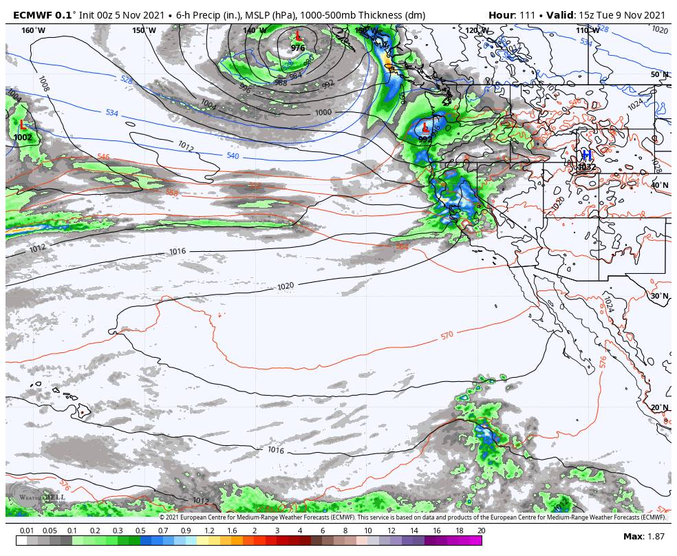
Monday – Tuesday Storm:

We have been watching a stronger storm headed towards the West Coast for Monday – Tuesday. As of the latest forecast model runs this morning, it still appears that the precipitation may hold off until late afternoon-evening on Monday. Increasing clouds and winds during the day Monday with ridgetop wind gusting to 80+ mph from the southwest. Highs in the 40s at the base and 30s for the upper mountain.

Steady rain and snow is expected for Monday night and Tuesday. Then showers possibly linger into Tuesday evening and then clearing Tuesday night. Snow levels are expected to fluctuate with this storm. Starting out around 7500-8000 ft. Monday evening and falling close to the base Monday night for several hours. Then rising again to 7500-8000 ft. Tuesday morning and dropping back to 6500-7000 ft. Tuesday afternoon, and then close the base again as the storm ends Tuesday evening.

Overall looking like a moderate 1-2 inch total precip storm. With the fluctuating snow levels, we could see snow accumulate at times on the lower mountain and then melt with rain before turning back to snow again. That makes making any snowfall forecasts tricky, but we could see between 1-9 inches from the base up to mid-mountain by Tuesday night. For the upper mountain, we could see 9-18 from mid-mountain to the top.

Ridgetop winds Tuesday gusting up to 100 mph. Highs in the 30s.

Long-Range:

It looks like high pressure will build over CA starting Wednesday through mid-month bringing us a drier pattern.

We will continue to watch the long-range trends for any signs of a stormier pattern returning. The mountain will be trying to make snow at night and hopefully more storms to help with natural snow. We will keep you updated on storms and when the mountain could open again later this month.

BA

lake tahoe weather palisades tahoe weather forecast snowfall forecast
Bryan Allegretto
Bryan Allegretto

Share this article:

Recent Posts

  • Weather ·
  • March 29, 2023·

Partly Sunny Wed-Sun w/ Snow Showers Possible

Snowfall Reports: 12 inches of new snow fell on the mountain in the past 24 hours as of 5 AM…
Read more
  • Weather ·
  • March 28, 2023·

Snow & Strong Winds Tuesday

Tuesday  – Wednesday Storm: Snow showers are pushing in Tuesday morning, with heavier snow expected later in the morning into…
Read more
  • Weather ·
  • March 27, 2023·

Snowstorm Tuesday, Snow Showers Wed-Sun

Monday: Monday will start out sunny with highs in the 30s at the base and 20s up top. Some high…
Read more

Social

Instagram Twitter Facebook Youtube

Contact

   Email Us
   1.800.403.0206

Our Partners

U.S. Forest Service Logo
1960 Olympic Valley Road
Olympic Valley, CA 96146

©2022 Palisades Tahoe

Alterra Mountain Company
  • Privacy Policy
  • Terms of Service
  • Photo Upload Terms of Use
  • Accessibility
  • Do Not Sell My Personal Information
  • Privacy Policy
  • Terms of Service
  • Photo Upload Terms of Use
  • Accessibility
  • Do Not Sell My Personal Information