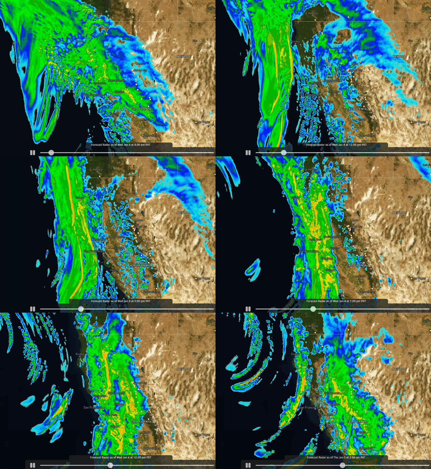
Wednesday – Thursday Storm:
The next storm is moving into northern CA Wednesday morning with snow showers spreading in across the Tahoe region with colder air in place. We could up to a few inches accumulate on the mountain through the morning hours. The winds aren’t that strong early Wednesday morning but are expected to ramp up pretty quickly by midday, with gusts from the south/southwest up to 80-90+ mph, which may close some lifts.
Southerly flow parallel to the Sierra may limit the heavy precip from reaching the mountain through Wednesday evening. Light-moderate snow showers are possible through the afternoon and evening but they could be scattered at times with lulls in the precip. Snow levels rise as warmer air pushes in. We could see some rain below 7000-7500 ft. for a time Wednesday into Wednesday evening.
Then a cold front pushes through later Wednesday night into Thursday morning with a period of heavier snow and falling snow levels. Snow levels drop below the base overnight. The snow becomes lighter behind the front Thursday afternoon and more scattered Thursday night before ending by early Friday morning.
Highs in the 30s Wednesday and dropping into the 20s on the upper mountain Thursday. Ridgetop gusts up to 60-70+ mph from the southwest Thursday morning which could still close some upper mountain lifts. Then dropping some through the afternoon. Here is my final snowfall forecast for this storm by Friday morning:
- 11-17 inches at the base. (a few inches of that falls before a change to rain)
- 17-23 inches at the mid-mountain elevations.
- 23-29 inches up top.

Friday:
We will see some sun and clouds between storms on Friday. A few scattered snow showers could fall around the region. The winds will be lighter so the skiing should be pretty good.. Highs in the 30s at the base and 20s up top.
Weekend Storm:
Clouds and winds increase Saturday morning with snow showers possible by Saturday afternoon. Ridgetop winds increase up to 70-80+ mph from the southwest by afternoon, which could close some upper mountain lifts.
Saturday night into Sunday morning we expect some heavier snow and falling snow levels as the cold front moves through. Snow levels fall below the base. Then lighter snow showers are possible for Sunday afternoon into Sunday evening possibly tapering off briefly overnight. Then increasing into early Monday morning as the next storm starts to move in.
Snow levels rise Sunday and could hover near the base again by Sunday afternoon into Sunday night, and then start to rise above the base early Monday morning. That means we could see wet snow with maybe some rain mixing in near the base Saturday and Sunday afternoon/night, with snow in between Saturday night into Sunday morning.
Ridgetop winds could continue to be fairly strong Sunday with gusts up to 70-80+ mph from the southwest through the day. That could cause more lift closures Sunday. Here is the updated snowfall forecast for the weekend storm through Sunday night.
- 8-14 inches at the base. (before a change to rain Sunday night)
- 14-16 inches at the mid-mountain elevations.
- 16-22 inches up top
Monday – Tuesday Storm:
The next storm could move in by Monday morning and lasts into Tuesday night. This storm looks warmer and could become quite wet by later Monday into Tuesday. Snow levels look to be quite high with this storm, up above 7500-8000 ft. for most of the storm possibly.
Heavy rain and high-elevation snow along with strong winds are expected. Not looking like good days to ski. We could see some flooding at the base and lift closures from winds and avalanche dangers on the upper mountain. Up top, several feet of snow are possible above 8000 ft.
Rain is expected to turn to snow at the end later Tuesday into Tuesday night. I’ll have more details on this storm through the weekend as the details become clearer.
Long-Range:
The latest long-range model runs suggest that we could possibly see a break in the storms next Wednesday the 11th through Thursday the 12th. But some models linger the Tuesday storm into Wednesday morning and bring in the next storm as early as Thursday.
The models show another storm moving in around Friday the 13th. The active pattern could continue into the 3rd week of January.
BA

