

Wednesday – Thursday:
Rain showers are falling around the region on Wednesday morning. Those showers will clear by the end of the day. Then a partly-mostly sunny day for Thursday. Highs in the 40s for the lower elevations to near 50 degrees by Thursday afternoon. 30s to near 40 degrees for the higher elevations. Ridgetop winds gusting up to 80+ mph on Wednesday morning and up to 60+ mph through Thursday.
Friday – Monday Rain & High Elevation Snow:
The forecast gets really complicated during this period as the models continue to get wetter as they aim a narrow atmospheric river right at the northern Sierra and the Tahoe basin for 4 days. Where that narrow band of heavy precipitation sits will not only determine totals but also high elevation snow levels. Be kind to forecasters with this complicated system.
The initial arrival of the rain is expected around Friday afternoon/evening and continuing into Friday night. Some models are showing a break during the day on Saturday before it takes aim at us again Saturday night through Sunday night, while some keep the rain going Saturday as well. Highs in the 30s for the upper elevations and 40s for the lower elevations near the base.
The latest model trend this morning is now for the AR to sag a bit south of Tahoe on Monday instead of lifting north. That may not only continue the precipitation but could lower the snow levels over the Tahoe basin. 4-day precipitation totals continue to increase with the models now showing up to 7-10 inches of precipitation over the mountain through Monday night!
Each forecast model has its own freezing level forecast (32 degrees), and snow levels can run up to 1000 ft. below the freezing levels. But during warmer AR events, they can only be up to 500 ft. lower unless it is precipitating very hard and dragging them lower. Add that to the difference in model forecasts for freezing levels, and the snow level forecast is an extremely hard science.
I do my best with 20 years of experience forecasting snow levels in the Sierra. The latest model runs show snow levels bouncing between 8000 – 9000 ft. for most of this storm through Sunday, with the lowest snow levels Saturday morning and highest on Sunday before falling again Sunday night. That means back and forth, rain to snow, is possible in that zone near the top of the mountain.
That means it’s very hard to forecast snow in that range. Where things get a lot more interesting is on Monday, where the trend is towards the AR sagging south a bit and colder air working in. If the latest model runs are right, snow levels could dip to near 7000 ft. on Monday, and maybe close to base at the end later Monday night.
With the heavy precipitation continuing, that means above the snow line, snow will accumulate quickly. But then, when snow levels fluctuate, rain can melt that snow quickly. So take my snowfall forecast with a grain of salt, as amounts could melt at times. Above 8k’ we could see 1-3 feet of wet snow (minus melting) if the snow levels dip close to 8k’ Saturday & Sunday night, and several inches up to a foot+ above 7k’ if they dip Monday.
If the AR lifts north as previously forecast, then snow levels don’t drop, and most of the snow will be confined to above 9k’ and totals would be less with lower snow ratios. We’ll continue to track this storm very closely over the next few days, as I don’t want to get everyone too excited if snow levels aren’t going to drop.
Tuesday:
The latest forecast model runs are suggesting the AR lifts north briefly on Tuesday as the trough digs south off the West Coast. Some model runs keep precipitation very close to Tahoe, but snow levels would rise. Tuesday is a question mark for precipitation chances in-between storms.
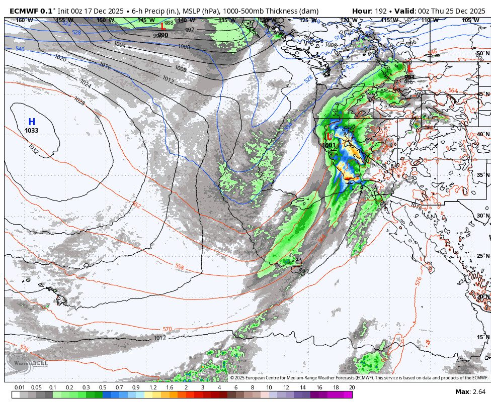
Christmas Storm:
We continue to be cautiously optimistic with the next storm that is forecast to push in on Christmas Eve and to continue into Christmas Day, with a few models lingering precipitation into the 26th. My fears about the trough being too far offshore that I have been mentioning each day are starting to show up on some models this morning.
The reason this is important is that this system will be drawing up copious amounts of subtropical moisture from the south. We need the cold air at the center of the trough and the low to push inland to get the lower snow levels. The models are split on how fast or even if this happens.
The position of the trough has been just barely far enough inland on the models for the last several days for a colder storm. Let’s hope the trend is towards the storm progressing inland and dropping snow levels to the base quickly on Christmas Eve into Christmas Day. If we get the colder air, then we could see significant snowfall on the mountain to the base.
Long-Range Outlook:
Beyond the 26th, the long-range models are trending towards another fear I have been mentioning, about the trough pulling north along with the storm track by the end of next week. If this trend continues on most models, then we are likely going to see a drier pattern around the 27th – 29th.
By the end of the month, the models are split with some showing a deeper trough digging south again with others keeping it farther north. Most of the ensemble mean models show a wet pattern in the Pacific NW, with a chance for weaker systems reaching northern CA the last few days of the month.
Hopefully, the storm track can stay far enough south for additional storms later in the month into January. What a stressful week for forecasting…
BA
