Skip to content
Palisades Tahoe Logo Palisades Tahoe Logo Palisades Tahoe Logo
Explore
Main Menu
  • Explore Palisades Tahoe
  • Base to Base Gondola
  • Our New Name
  • Explore Legendary Lifts
  • Palisades Tahoe Blog
  • About Lake Tahoe
  • About Us
Plan Your Visit
Main Menu
  • Tickets & Passes
  • Lodging
  • Lessons & Guides
  • Deals & Packages
  • Rentals & Demos
  • Travel Here
  • Getting Around
Mountain Information
Main Menu
  • Snow and Weather
  • Lift and Grooming Status
  • Webcams
  • Hours of Operation
  • Trail Maps
  • Parking & Road Conditions
  • Snowfall Tracker
Events & Activities
Main Menu
  • Events Calendar
  • Activities
  • Dining & Apres
  • Shopping
  • Things To Do In Lake Tahoe
  • Groups, Meetings & Weddings
  • Ski & Snowboard Teams
IKON PASS HOLDER LODGING DISCOUNT

Ikon Pass holders save up to 20% on slopeside lodging at The Village at Palisades Tahoe.

SLOPESIDE LODGING
Icon / FlashCreated with Sketch.
View All Offers
  • Weather

Quick Cool Down Tuesday, Then A Mild Thanksgiving

  • Nov 21, 2021
  • 8:01 am

Sunday – Monday:

The dry pattern continues with clear skies through Monday. Highs in the 40s Sunday and into the 50s Monday as high pressure over the region begins to start shifting east. The snowmaking at night looks marginal but with breezy winds maybe we can make a little both nights on the mid-upper mountain.

Tuesday – Wednesday:

A split trough swings through Tuesday bringing some colder air but staying dry with low-pressure systems staying to our north and south. The good news is that the nights will be colder Tuesday and Wednesday night with lows into the 20s for most elevations. That should bring the best night for snowmaking Tuesday night and even with inversions starting Wednesday night we may still get a decent night, especially for the lower mountain.

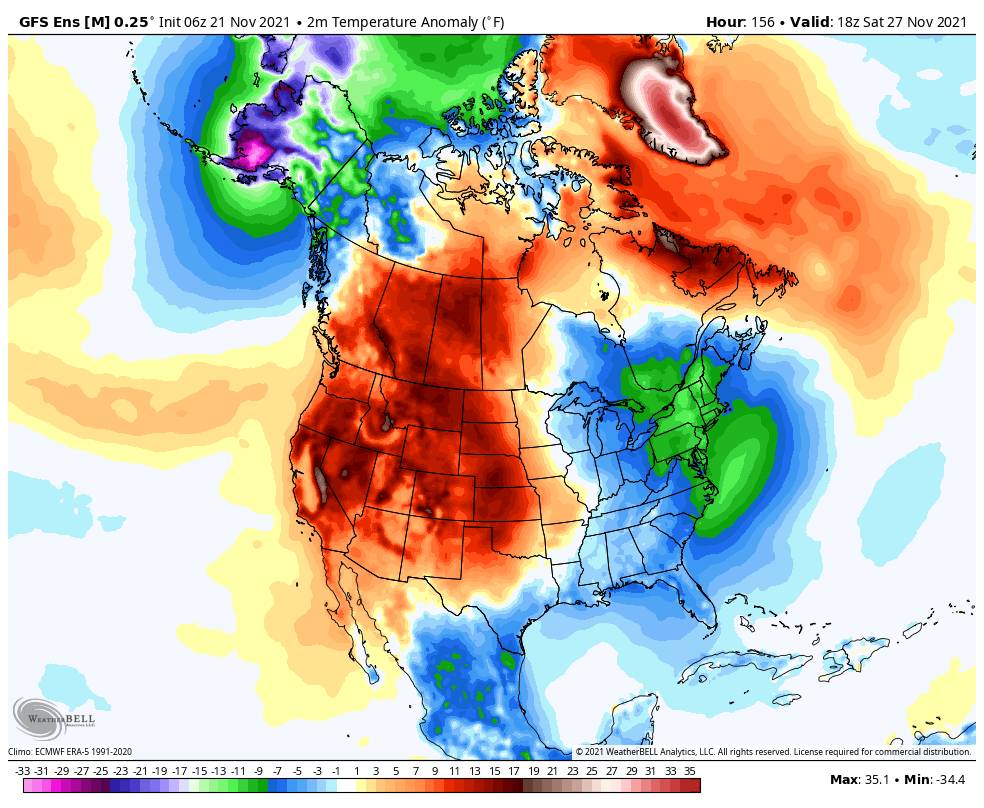
Thanksgiving Day thru The Weekend:

By Thanksgiving Day through next weekend, we are expecting a strong high-pressure ridge to build over the region bringing dry and mild weather. We will see mild weather with highs into the 50s starting Thursday. Unfortunately, it looks like both milder temperatures and overnight inversions may keep any snowmaking to the lowest elevations or make it impossible completely.

Long-Range:

The latest forecast model runs show us staying dry through at least the daytime hours of the 30th.

As we start the 1st week of December, the long-range models are trying to start shifting the pattern right away in the new month. They are in decent agreement in breaking down the large ridge over the West and replacing it with a flatter ridge off the CA coast.

A large trough in the northeast Pacific is forecast to see storms start spinning up in it and moving into the Pacific NW through the 1st week of December. With the flat ridge off the coast, we would be on the southern edge of the storms, but we could see a few weak systems starting as early as the night of the 30th. Through the 1st few days of December, the long-range models show light amounts of precip starting to add up.

As we go towards the end of the 1st week of December we may see a deeper trough down the West Coast which would allow for the storms to dig farther south and bring us wetter storms potentially. That will be the focus over the next 10 days. Let’s hope we can get things going as we go into December.

BA

lake tahoe weather palisades tahoe weather forecast snowfall forecast
Bryan Allegretto
Bryan Allegretto

Share this article:

Recent Posts

  • Weather ·
  • February 4, 2023·

A 24-hour Dump of Snow

Snowfall Report: No surprises with the weak and windy system that moved through Friday as it dropped 1 inch on…
Read more
  • Weather ·
  • February 3, 2023·

Windy Friday, Snowstorm Sat Night – Sunday

Windy Friday System: A weak system moves through Friday with some light rain & snow showers possible. Ridgetop winds gusting…
Read more
  • Weather ·
  • February 2, 2023·

Windy w/ A Few Snow Showers Friday

Thursday: Partly sunny Thursday with increasing high clouds. Highs warming into the 30s up top 40s for the lower at…
Read more

Social

Instagram Twitter Facebook Youtube

Contact

   Email Us
   1.800.403.0206

Our Partners

U.S. Forest Service Logo
1960 Olympic Valley Road
Olympic Valley, CA 96146

©2022 Palisades Tahoe

Alterra Mountain Company
  • Privacy Policy
  • Terms of Service
  • Photo Upload Terms of Use
  • Accessibility
  • Do Not Sell My Personal Information
  • Privacy Policy
  • Terms of Service
  • Photo Upload Terms of Use
  • Accessibility
  • Do Not Sell My Personal Information