Palisades Tahoe Logo Palisades Tahoe Logo Palisades Tahoe Logo
Explore
  • Explore Palisades Tahoe
  • Our New Name
  • Explore Legendary Lifts
  • Palisades Tahoe Blog
  • About Lake Tahoe
  • About Us
Plan Your Visit
  • Tickets & Passes
  • Lodging
  • Lessons & Guides
  • Deals & Packages
  • Rentals & Demos
  • Travel Here
  • Getting Around
Mountain Information
  • Snow and Weather
  • Lift and Grooming Status
  • Webcams
  • Hours of Operation
  • Trail Maps
  • Parking & Road Conditions
  • Snowfall Tracker
Events & Activities
  • Events Calendar
  • Activities
  • Dining & Apres
  • Shopping
  • Things To Do In Lake Tahoe
  • Groups, Meetings & Weddings
  • Ski & Snowboard Teams
IKON PASS HOLDER LODGING DISCOUNT

Ikon Pass holders save up to 25% on slopeside lodging at The Village at Palisades Tahoe.

SLOPESIDE LODGING
Icon / FlashCreated with Sketch.
View All Offers
  • Weather

Nicer Weather Ahead, Still Stuck in A Dry Pattern

  • Feb 3, 2022
  • 8:50 am

Thursday:

Sunny skies again for Thursday but not as cold as Wednesday. Highs into the 30s. The gusty northeast winds have come down and are only gusting up to 40+ mph up top Thursday morning, and may come down more during the afternoon.

The Weekend:

Friday into the weekend high pressure rebuilds over the West Coast. That will bring back highs into the 40s at the base & 30s up top. The dry pattern and sunny skies continue. Lighter winds Friday and northeast winds gusting up to 30+ mph up top Saturday, then lighter again Sunday.
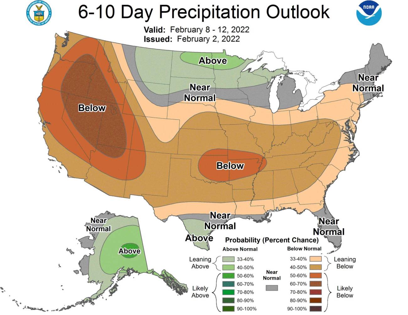
Long-Range:

High pressure is forecast to stay near the West coast through the 2nd week of February. That should keep us in a dry pattern for at least another 10+ days.

There are some signs that high pressure could start to shift away from the West Coast starting after mid-month. That may allow in some colder air and weak systems but keeps us in a mainly dry pattern into the 3rd week of February.

We’re hoping the pattern shifts more later in the 3rd week of February into the last week allowing storms to return. We’ll let you know at the first sign of any storms headed our way!

BA

lake tahoe weather palisades tahoe weather forecast snowfall forecast
Bryan Allegretto
Bryan Allegretto

Share this article:

Recent Posts

  • Weather ·
  • May 26, 2022·

Colder with Unsettled Weather for Memorial Day Weekend

It’s the last weekend of the season and we could see a few flakes fall on the mountain! Thursday –…
Read more
  • Weather ·
  • May 17, 2022·

Quick Cooldown Thu-Fri, Then Milder Weather

A cool trough moves through Thursday – Friday. Highs dip down into the 60s at the base Thursday and 50s…
Read more
  • Weather ·
  • May 11, 2022·

After 15″ of Snow, A Return to Spring

Snowfall Report: We have had a cold and wintry first half of the week with several systems that rotated through…
Read more

Social

Instagram Twitter Facebook Youtube

Contact

   Email Us
   1.800.403.0206

Our Partners

U.S. Forest Service Logo
1960 Squaw Valley Road
Olympic Valley, CA 96146

©2022 Palisades Tahoe

Alterra Mountain Company
  • Privacy Policy
  • Terms of Service
  • Photo Upload Terms of Use
  • Accessibility
Menu
  • Privacy Policy
  • Terms of Service
  • Photo Upload Terms of Use
  • Accessibility