
The Weekend
Strong high-pressure is over CA for Christmas weekend. Saturday and Sunday we will see mostly sunny skies, lighter winds, & mild temperatures. Highs in the 40s on the mountain and near 50 degrees at the base both days.
Monday
Highs in the 40s for Monday with increasing clouds and winds. Ridgetop gusts from the southwest up to 40+ mph to start the day and increasing up to 70+ mph during the afternoon, which could affect some upper mountain lift operations by later in the day.
Monday Night – Tuesday Night Storm
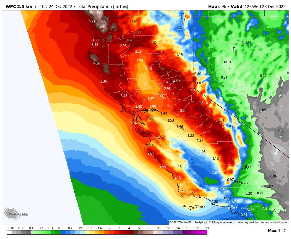
The first storm is expected to move in with light rain showers as early as Monday evening. This storm will be tapping into quite a bit of subtropical moisture with heavy rain moving in after midnight into early Tuesday morning from top to bottom.
For Tuesday, temperatures will be in the 30s, and ridgetop winds will be gusting up to 100+ mph over the ridges. Those winds should close down quite a few ski lifts. The tricky part of the forecast will be how fast do the snow levels fall with the cold front through the day on Tuesday as the heaviest precipitation shifts south of the area.
Snow levels could drop fairly quickly down to 8,000 ft by mid-morning and 7000 ft. by midday. Then down to between 6000-6500 ft. by late afternoon. That is near to just above the base at Palisades and below the base on the Alpine side. Heavy wet snow will fall on the mountain as the rain turns to snow through the day from top to bottom, with several inches up to a foot possible on the upper mountain.
Tuesday night snow levels fall below the base but with lighter snow showers expected. A few more inches of drier snow are possible overnight. It’s very hard to forecast total snowfall with the rain, but looking at the model average for snow levels & precip, we could see 2-8 inches at the base & lower mountain, 8-13 inches at mid-mountain, and 13-18 inches on the upper mountain by Wednesday morning.
Wednesday – Wednesday Night
Some forecast models show a break between storms Wednesday, while others show snow showers continuing. Then some models show the next storm moving in Wednesday night into Thursday while others hold off until Thursday night. We will have to fine-tune the details on timing as the storms get closer. Overall we could see snow showers both Wednesday and Wednesday night.
The winds should come down Wednesday with ridgetop gusts up to 40+ mph. Highs in the 30s. Snow levels stay below the base through Wednesday night. We could see an additional 4-8 inches of snow at the base and 5-10 inches on the mountain by Thursday morning. Wednesday could be a decent day weather-wise for skiing.
Long-Range
The next storm could continue Thursday with additional storms possible Thursday night into Friday and Friday night into New Year’s Eve. Each storm could be quite wet and windy. We could see snow levels start higher with each storm and then fall with each cold front. Strong winds with each could affect lift operations throughout the week and into New Year’s weekend.
The storms look a little colder than the Tuesday storm, so the upper mountain may see mostly snow through the period and it could pile up to several feet by New Year’s Day. We will fine-tune the snow level and snowfall forecasts as each storm gets closer.
The active pattern could continue into the first week of January including a storm the night of the 1st. You’ll want to stay tuned to the forecast as we iron out the details on timing for each storm, especially if you plan to travel through the Sierra through the holiday period.
BA


