Palisades Tahoe Logo Palisades Tahoe Logo Palisades Tahoe Logo
Explore
  • Explore Palisades Tahoe
  • Our New Name
  • Explore Legendary Lifts
  • Palisades Tahoe Blog
  • About Lake Tahoe
  • About Us
Plan Your Visit
  • Tickets & Passes
  • Lodging
  • Lessons & Guides
  • Deals & Packages
  • Rentals & Demos
  • Travel Here
  • Getting Around
Mountain Information
  • Snow and Weather
  • Lift and Grooming Status
  • Webcams
  • Hours of Operation
  • Trail Maps
  • Parking & Road Conditions
  • Snowfall Tracker
Events & Activities
  • Events Calendar
  • Activities
  • Dining & Apres
  • Shopping
  • Things To Do In Lake Tahoe
  • Groups, Meetings & Weddings
  • Ski & Snowboard Teams
IKON PASS HOLDER LODGING DISCOUNT

Ikon Pass holders save up to 25% on slopeside lodging at The Village at Palisades Tahoe.

SLOPESIDE LODGING
Icon / FlashCreated with Sketch.
View All Offers
  • Weather

Mostly Sunny Skies Prevail

  • Dec 1, 2020
  • 8:45 am

The 1st Week of December:

The latest forecast model runs continue to show a dry pattern for CA through the 1st week of December as high pressure builds in over the West Coast. Mostly sunny skies should continue. Highs in the 40s on the mountain to near 50 degrees at the base by Friday.

We may see inversions with the colder temperatures at the base and warmer up top. That could make temperatures a bit too warm up top for snowmaking, but it should remain below freezing on the lower mountain for continued snowmaking and terrain expansion.

Long-Range:

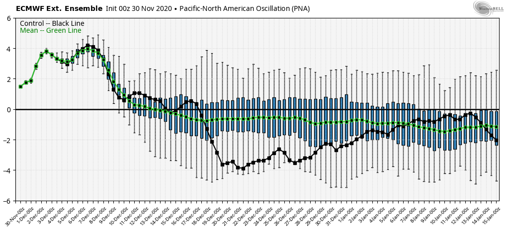
The pattern may not shift enough for the chance to see a storm until at least the 10th-11th of December. The latest model runs show the PNA (Pacific North American) pattern shifting back towards the negative phase and the high-pressure ridge shifting just off the West Coast. That could allow a cold weak system to drop down from the north around the 10th-11th, and then possibly another system around mid-month.

We may see a better chance for storms to return during the 3rd week of December into the last week of the month. I’m not seeing a pattern yet that would set us up for a series of bigger storms. I will continue to monitor the long-range patterns and we will let you know when storms are inbound.

BA

lake tahoe weather snowfall forecast squaw snow Squaw Weather Forecast
Bryan Allegretto
Bryan Allegretto

Share this article:

Recent Posts

  • Weather ·
  • May 26, 2022·

Colder with Unsettled Weather for Memorial Day Weekend

It’s the last weekend of the season and we could see a few flakes fall on the mountain! Thursday –…
Read more
  • Weather ·
  • May 17, 2022·

Quick Cooldown Thu-Fri, Then Milder Weather

A cool trough moves through Thursday – Friday. Highs dip down into the 60s at the base Thursday and 50s…
Read more
  • Weather ·
  • May 11, 2022·

After 15″ of Snow, A Return to Spring

Snowfall Report: We have had a cold and wintry first half of the week with several systems that rotated through…
Read more

Social

Instagram Twitter Facebook Youtube

Contact

   Email Us
   1.800.403.0206

Our Partners

U.S. Forest Service Logo
1960 Squaw Valley Road
Olympic Valley, CA 96146

©2022 Palisades Tahoe

Alterra Mountain Company
  • Privacy Policy
  • Terms of Service
  • Photo Upload Terms of Use
  • Accessibility
Menu
  • Privacy Policy
  • Terms of Service
  • Photo Upload Terms of Use
  • Accessibility