Palisades Tahoe Logo Palisades Tahoe Logo Palisades Tahoe Logo
Explore
  • Explore Palisades Tahoe
  • Our New Name
  • Explore Legendary Lifts
  • Palisades Tahoe Blog
  • About Lake Tahoe
  • About Us
Plan Your Visit
  • Tickets & Passes
  • Lodging
  • Lessons & Guides
  • Deals & Packages
  • Rentals & Demos
  • Travel Here
  • Getting Around
Mountain Information
  • Snow and Weather
  • Lift and Grooming Status
  • Webcams
  • Hours of Operation
  • Trail Maps
  • Parking & Road Conditions
  • Snowfall Tracker
Events & Activities
  • Events Calendar
  • Activities
  • Dining & Apres
  • Shopping
  • Things To Do In Lake Tahoe
  • Groups, Meetings & Weddings
  • Ski & Snowboard Teams
IKON PASS HOLDER LODGING DISCOUNT

Ikon Pass holders save up to 25% on slopeside lodging at The Village at Palisades Tahoe.

SLOPESIDE LODGING
Icon / FlashCreated with Sketch.
View All Offers
  • Weather

Mild Fri – Sat, Slightly More Active Sun – Tue

  • Mar 11, 2022
  • 6:35 am

Friday – Saturday:

High pressure is sitting over CA Friday into Saturday. We are expecting mostly sunny skies with highs into the 50s at the base and 40s up top. Lighter winds Friday into Saturday morning. Then the winds ramp up from the southwest through Saturday afternoon with ridgetop gusts up to 60+ mph by the end of the ski day. That could affect some upper mountain lifts by the end of the day on Saturday.

Saturday Night – Sunday System:

The next system for Saturday night into Sunday will likely bring some clouds and gusty winds. Ridgetop gusts up to 80+ mph early Sunday morning could delay some upper mountain lift openings. Then falling through the afternoon. Highs drop into the 40s at the base and 30s up top.

We could see a few light snow showers move through later Saturday night into Sunday morning. The amounts look light. Snow levels look to be near to below the base. We could see a coating to an inch of new snow on the upper mountain.
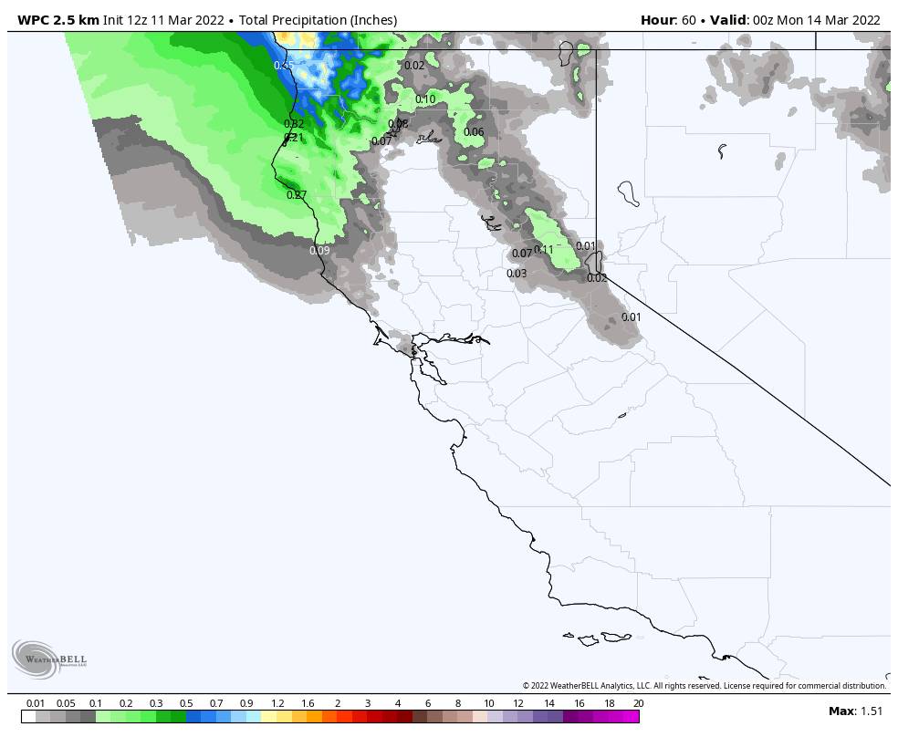
Monday:

A quick rebound back to nicer weather Monday with mostly sunny skies and highs back into the 50s at the base and 40s up top, along with lighter winds.

Tuesday System:

Another system digs south into the northern Sierra by early Tuesday morning. This system should bring a bit more moisture south into the Tahoe Basin. We could see rain showers at the base and snow showers up top into Tuesday afternoon before the storm clears out by Tuesday night.

Snow levels look to start above 8000 ft. and fall to 7000 ft. Tuesday. Maybe slightly lower at times if we see some heavier showers. Ridgetop winds gusting up to 80+ mph from the southwest, likely causing some lift closures Tuesday morning, then falling through the afternoon. Expecting rain at the base and part of the lower mountain, with 1-5 inches of snow on the upper mountain above 7000 ft.

Long-Range:

Right now Wednesday through next Friday look to be drier and milder. We may stay in a similar pattern through the long-range. The Pacific NW could stay active with Northern CA on the southern edge of the storm track. 

The next chance for a storm to bring rain & snow to the Northern Sierra looks to be the weekend of the 19th. We’ll continue to watch the trends as we get closer.

BA

lake tahoe weather palisades tahoe weather forecast snowfall forecast
Bryan Allegretto
Bryan Allegretto

Share this article:

Recent Posts

  • Weather ·
  • May 26, 2022·

Colder with Unsettled Weather for Memorial Day Weekend

It’s the last weekend of the season and we could see a few flakes fall on the mountain! Thursday –…
Read more
  • Weather ·
  • May 17, 2022·

Quick Cooldown Thu-Fri, Then Milder Weather

A cool trough moves through Thursday – Friday. Highs dip down into the 60s at the base Thursday and 50s…
Read more
  • Weather ·
  • May 11, 2022·

After 15″ of Snow, A Return to Spring

Snowfall Report: We have had a cold and wintry first half of the week with several systems that rotated through…
Read more

Social

Instagram Twitter Facebook Youtube

Contact

   Email Us
   1.800.403.0206

Our Partners

U.S. Forest Service Logo
1960 Squaw Valley Road
Olympic Valley, CA 96146

©2022 Palisades Tahoe

Alterra Mountain Company
  • Privacy Policy
  • Terms of Service
  • Photo Upload Terms of Use
  • Accessibility
Menu
  • Privacy Policy
  • Terms of Service
  • Photo Upload Terms of Use
  • Accessibility