Palisades Tahoe Logo Palisades Tahoe Logo Palisades Tahoe Logo
Explore
  • Explore Palisades Tahoe
  • Our New Name
  • Explore Legendary Lifts
  • Palisades Tahoe Blog
  • About Lake Tahoe
  • About Us
Plan Your Visit
  • Tickets & Passes
  • Lodging
  • Lessons & Guides
  • Deals & Packages
  • Rentals & Demos
  • Travel Here
  • Getting Around
Mountain Information
  • Snow and Weather
  • Lift and Grooming Status
  • Webcams
  • Hours of Operation
  • Trail Maps
  • Parking & Road Conditions
  • Snowfall Tracker
Events & Activities
  • Events Calendar
  • Activities
  • Dining & Apres
  • Shopping
  • Things To Do In Lake Tahoe
  • Groups, Meetings & Weddings
  • Ski & Snowboard Teams
IKON PASS HOLDER LODGING DISCOUNT

Ikon Pass holders save up to 25% on slopeside lodging at The Village at Palisades Tahoe.

SLOPESIDE LODGING
Icon / FlashCreated with Sketch.
View All Offers
  • Weather

Midweek Cold Front with Maybe a Dusting

  • Mar 8, 2022
  • 7:04 am

Tuesday – Wednesday:

We will see mostly sunny skies Tuesday with highs into the 40s at the base and 30s up top.

We are expecting similar weather again during the day on Wednesday, but the ridgetop winds could be a bit gustier from the northwest. Exposed ridges could see gusts of 40-50+ mph. 

Wednesday Night – Thursday Cold Front:

Wednesday night into early Thursday morning a cold front sweeps through the region from north to south. The Sierra will be on the western edge of the cold trough and band of precipitation moving through with the cold front.

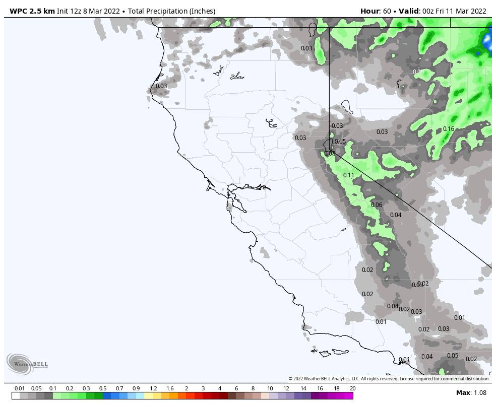
The latest model runs continue to show nothing up to a tenth of an inch of precipitation through the Tahoe Basin through Thursday morning. Enough for only a dusting of snow likely on the mountain at best.

Colder air moves in for Thursday with highs in the 30s at the base and 20s up top as the sun comes back out behind the front later in the morning. Ridgetop winds increase and turn northeast with gusts of 60-70+ mph Thursday morning, and then dropping through the afternoon. That could cause a few early morning upper mountain lift delays.

Friday – Saturday:

High pressure quickly builds back in over CA Friday into Saturday and we will warm up quickly. We are expecting mostly sunny skies with highs jumping into the 50s at the base and 40s up top both days. Friday could be the nicest day of the week.

Saturday is expected to be sunny & mild, but an active pattern is about to return to the Pacific NW with a storm by Sunday, so the latest model runs show winds ramping up quite a bit through Saturday afternoon with ridgetop gusts up to 70+ mph by the end of the ski day, and even higher Saturday night. That could close some upper mountain lifts by the end of the day on Saturday.

Long-Range:

Starting Sunday through the 3rd week of March they continue to show a ridge over the southwest and southern CA, and trough pushing into the Pacific NW with storms every 2-3 days. The ridge will be trying to keep the storm track to our north and the troughs will be trying to flatten the ridge and push precipitation south into northern CA. It’s hard to say if and how much precipitation could reach the Tahoe Basin with each system with us being the southern edge of the storm track.

The first system Sunday could bring light rain & snow showers but looks to mainly stay to our north. The next storm that moves in by next Tuesday the models show possibly digging a bit farther south with the heavier precipitation. So we will be keeping an eye on both this week. 

BA

lake tahoe weather palisades tahoe weather forecast snowfall forecast
Bryan Allegretto
Bryan Allegretto

Share this article:

Recent Posts

  • Weather ·
  • May 26, 2022·

Colder with Unsettled Weather for Memorial Day Weekend

It’s the last weekend of the season and we could see a few flakes fall on the mountain! Thursday –…
Read more
  • Weather ·
  • May 17, 2022·

Quick Cooldown Thu-Fri, Then Milder Weather

A cool trough moves through Thursday – Friday. Highs dip down into the 60s at the base Thursday and 50s…
Read more
  • Weather ·
  • May 11, 2022·

After 15″ of Snow, A Return to Spring

Snowfall Report: We have had a cold and wintry first half of the week with several systems that rotated through…
Read more

Social

Instagram Twitter Facebook Youtube

Contact

   Email Us
   1.800.403.0206

Our Partners

U.S. Forest Service Logo
1960 Squaw Valley Road
Olympic Valley, CA 96146

©2022 Palisades Tahoe

Alterra Mountain Company
  • Privacy Policy
  • Terms of Service
  • Photo Upload Terms of Use
  • Accessibility
Menu
  • Privacy Policy
  • Terms of Service
  • Photo Upload Terms of Use
  • Accessibility