Skip to content
Palisades Tahoe Logo Palisades Tahoe Logo Palisades Tahoe Logo
Explore
Main Menu
  • Explore Palisades Tahoe
  • Base to Base Gondola
  • Our New Name
  • Explore Legendary Lifts
  • Palisades Tahoe Blog
  • About Lake Tahoe
  • About Us
Plan Your Visit
Main Menu
  • Tickets & Passes
  • Lodging
  • Lessons & Guides
  • Deals & Packages
  • Rentals & Demos
  • Travel Here
  • Getting Around
Mountain Information
Main Menu
  • Snow and Weather
  • Lift and Grooming Status
  • Webcams
  • Hours of Operation
  • Trail Maps
  • Parking & Road Conditions
  • Snowfall Tracker
Events & Activities
Main Menu
  • Events Calendar
  • Activities
  • Dining & Apres
  • Shopping
  • Things To Do In Lake Tahoe
  • Groups, Meetings & Weddings
  • Ski & Snowboard Teams
IKON PASS HOLDER LODGING DISCOUNT

Ikon Pass holders save up to 20% on slopeside lodging at The Village at Palisades Tahoe.

SLOPESIDE LODGING
Icon / FlashCreated with Sketch.
View All Offers
  • Weather

Light Snow Wednesday Night

  • Dec 29, 2020
  • 8:19 am

Tuesday – Wednesday:

Mostly sunny skies on Tuesday. Highs in the 30s. Gusty northeast winds Tuesday morning with gusts to 60+ mph up top, dropping some for the afternoon with gusts to 40+ mph.

Wednesday we may see some sun in the morning and increasing clouds in the afternoon as the next system approaches. Winds increasing again in the afternoon from the southwest with ridgetop gusts to 60+ mph by evening.

Wednesday Night Snow:

A weak system will move in Wednesday night around 7-9 PM and will clear out Thursday morning. Expecting low snow levels and snow ratios up to 15:1 up top with a drier snow. We could see 1-3 inches of new snow at the base and 2-5 inches on the mountain by Thursday morning.

Thursday – Friday:

Clearing through the Thursday day with mostly sunny skies by afternoon. Highs in the 30s at the base and 20s up top. Winds coming down during the day on Thursday. Friday we should start the day with mostly sunny skies and then clouds could start streaming in later in the day. Highs in the 30s.
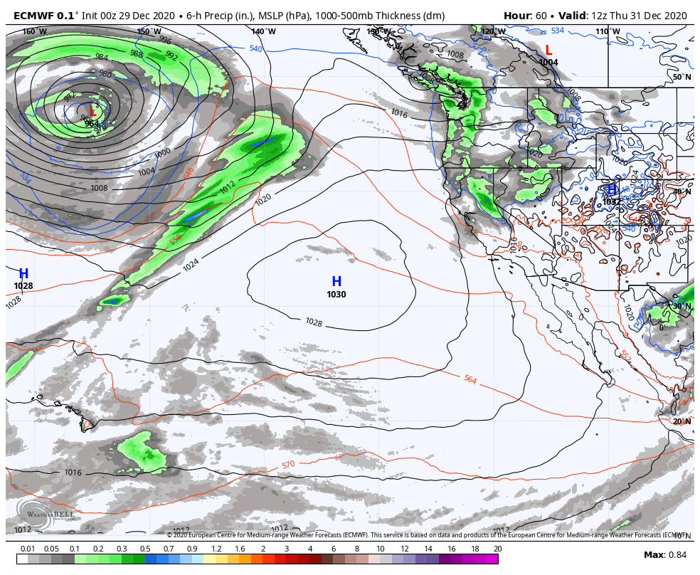
Weekend Storm:

The next storm takes aim at the Pacific NW on Saturday. We may be on the southern edge of moisture streaming into off the Pacific. We will have to watch how far south that stream pushes as it is fairly stationary during the day. We could see just clouds, or we could see very light snow showers with 1-2 inches of snow on Saturday.

Saturday night into Sunday the trough digs south into CA pushing heavier precipitation into the northern Sierra. There are big discrepancies on how much moisture this front holds onto as it shifts south through CA. Some models show only 2 inches of additional snowfall while others show up to 2 feet. For now we will go with 6-12 inches and fine-tune that as we get closer.

Long-Range:

The pattern looks to remain active with additional storms moving through northern CA most of next week. The first storm may move in Monday, with more storms behind that through Friday. If the current forecast holds, it could be a snowy week ahead starting this weekend. 

We will have to track each storm to see the exact track and how much moisture they will pull in for accumulating snowfall on the mountain. More details as we get closer to each storm.

BA

weather
Bryan Allegretto
Bryan Allegretto

Share this article:

Recent Posts

  • Weather ·
  • March 21, 2023·

Weak Systems & Snow Showers thru Sunday

Tuesday Storm: The next storm pushes snow showers back in by later Tuesday morning, with steadier snow through Tuesday afternoon.…
Read more
  • Weather ·
  • March 20, 2023·

More Weak Systems Tuesday-Friday

Snowfall Reports: No real surprises with the weak storm that moved through on Sunday. We were expecting 3-11 inches from…
Read more
  • Weather ·
  • March 19, 2023·

Two More Storms Sun & Tue

Sunday Storm: Snow showers are moving in Sunday morning, and will continue through the day before becoming more scattered Sunday…
Read more

Social

Instagram Twitter Facebook Youtube

Contact

   Email Us
   1.800.403.0206

Our Partners

U.S. Forest Service Logo
1960 Olympic Valley Road
Olympic Valley, CA 96146

©2022 Palisades Tahoe

Alterra Mountain Company
  • Privacy Policy
  • Terms of Service
  • Photo Upload Terms of Use
  • Accessibility
  • Do Not Sell My Personal Information
  • Privacy Policy
  • Terms of Service
  • Photo Upload Terms of Use
  • Accessibility
  • Do Not Sell My Personal Information