

Tuesday Showers:
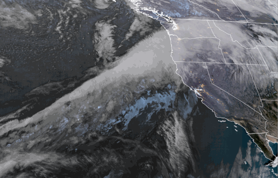
The cold front has draped itself across the northern Sierra as of Monday morning. That has brought in some colder air for Monday. Highs will be in the 30s to near 40 degrees for the lower elevations near the base. Clouds and moisture are streaming into the Pacific NW, with moisture finally off the West Coast after a very dry 5-week period.
We will see clouds stream in for Monday, but we are not expecting any precipitation or snow during the day. Moisture increases along the front Monday night, but may stay to the south of the Tahoe Basin. Then lifting north on Tuesday with snow showers increasing by afternoon.
This is the weak part of the storm, with lighter precipitation and snowfall expected. It’s also the warmest part with snow levels starting around 6000 – 6500 ft. Monday evening, falling to around 5500 – 6000 ft. Tuesday morning, and then rising up to 6500 – 7000 ft. Tuesday afternoon, ahead of the low-pressure system approaching the coast. Highs in the 30s.
Tuesday Night Wednesday Snow:
The low-pressure system spinning up off the coast will move inland Tuesday night and will move across the region into Wednesday. That will bring the steadiest round of precipitation Tuesday night, with snow showers lingering into Wednesday evening before the system clears the region.
Snow levels fall overnight, down to around 4500-5500 ft. by Wednesday morning. Then rising up to 6000 – 6500 ft. by Wednesday afternoon as the showers become more scattered, and dropping again on Wednesday night as the system moves away. Highs in the 30s for the lower elevations on Wednesday and 20s for the higher elevations.
The snowfall forecasts below 7000 ft. down to the base are trickier, as it will depend on how fast snow levels drop during steadier rounds of precipitation. During lulls and lighter showers, we could see some rain. Up on the mountains ~8k’, the snow ratios through Wednesday could average around 12:1 during the 2-day storm.
My updated snowfall forecast for the 2-day period, between Monday Night and Wednesday evening, is for around 4-8 inches at the baes, 6-11 inches near mid-mountain, and 8-13 inches up top.
Thursday – Friday Break:
We are still expecting a break in the storm on Thursday and Friday, with mostly sunny skies possible. Highs in the 30s and near 40 degrees for the lower elevations near the base on Friday.
President’s Day Weekend:
I’m only going to talk about Saturday – Sunday in this section, as it is now with the 7-day window, but it’s the start of a pattern change that could bring a cold storm series into the week of the 16th. It’s still too early to look at specific details among the operational models, and they disagree on the timing of the first storm with the change in the pattern coming starting over the weekend.
Some forecast model runs suggest the first storm could arrive as early as Saturday, while others wait until as late as next Monday. That makes for a very uncertain weekend forecast right now. The model average is for Saturday to mainly stay dry and cold, but will have increasing clouds and winds ahead of the first storm.
Then, snow and gusty winds are possible for Sunday as the first storm begins to bring snow to the northern Sierra. We’ll be watching the trends on the timing of the first system all week.
Cold & Stormy Pattern:
The long-range models continue to show a deep trough opening the door to cold storms over the West Coast by Sunday through the 19th. The latest model runs continue to show a series of cold storms spinning up into the base of the trough and moving through the Sierra with almost continuous precipitation through the period.
The latest operational model runs show storms through Wednesday, and maybe ending by Wednesday night, the 18th, or Thursday, the 19th. We’ll continue to watch the trends on the timing and details of each storm over the next week.
I would not be worried about the snow levels with these storms, as we are expecting highs in the 20s for the lower elevations, and teens for the higher elevations, with high snow ratios and powdery snow through the period.
The OpenSnow storm snowfall total charts, by model and run, continue to show some big snowfall totals possible over the period. We’ll continue to watch the trends closely, with more details on daily snowfall amounts as we get storms within the 5-day forecast window.
Long-Range Outlook:
The long-range models continue to show the trough slowly lifting north beyond the 19th, but possibly still far enough south for another storm or two to reach the northern Sierra through about the 23rd, as the storm track shifts north with time. We’ll keep an eye on that as well.
During the last 4-5 days of the month, the longer-range models continue to suggest that the trough and storm track continue to shift north, with the mean trough position up over the Canadian west coast by the end of the month. That would eventually shift the storm track far enough north that we may shift back into a drier pattern late in the month.
That is still far enough away to change as we get closer, and is after we get through storms finally returning over the next 10 – 14 days.
BA
