

Dry & Mild Weather
The partly-mostly sunny days and mild temperatures will continue through the weekend, as we wait for the high-pressure ridge over the West to continue to slowly weaken and shift east out of the region.
High temperatures will be in the 60s for the lowest elevations each day, 50s near mid-mountain elevations, and 40s for the highest peaks.
The Pattern Change Begins:
Monday will be a transition day as a cold trough begins to push into the region. We will see some clouds, increasing winds, and highs dropping around 10 degrees from Sunday’s highs.
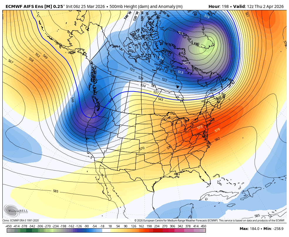
Winter Returns:
The trough progresses inland through next week, opening the door to a pair of storms between Monday night and Friday morning.
The latest model runs show precipitation from the first storm moving into the northern Sierra by Monday night, with back-to-back systems with no break in the precipitation on most models through Thursday. Then, clearing out by Friday.
The first system is trending wetter on the latest model runs as it taps into some subtropical moisture. Overall, the latest model runs have been increasing the precipitation forecasts for the 3-day period by around an inch over the past 24 hours. They now show up to 2.5 – 4 inches falling.
As is usual during a shift from a warm to cold pattern and storms returning, we will see increasing winds with strong ridgetop gusts by Tuesday into Wednesday, with ridgetop winds gusting up to 60-70+ mph. That could affect the upper mountain ski lifts.
By Tuesday, high temperatures for the lowest elevations near the base drop into the 40s, and then 30s Wed – Fri as the colder storm moves through. Near 8000 ft., highs drop into the 30s by Tuesday and then 20s for Wed – Fri. That is good news as the snow base on the mountain will finally start to freeze and firm up a little.
The first storm moving in from the West and tapping subtropical moisture will be milder, with snow levels possibly only dropping to around 7000 ft. by Tuesday. Some models show them dipping closer to the base. Then the colder storm Wed – Thu drops snow levels well below the base.
It’s still early to lock in bets or belief in potential snowfall amounts with the storms, especially for the lower elevations, as we are still 5.5 days from the start of the 1st storm. I will start to make my own detailed snowfall forecast as the storms move into the 5-day forecast window. Early estimates are for 1-2 feet for the lower mountain and 2-3 feet for the upper mountain by Friday, the 3rd.
Long-Range Outlook:
The latest forecast model runs clear out the snow by Friday with mostly sunny skies returning into the first weekend in April. Going into the week of the 6th, the long-range models show high pressure building off the West Coast, but staying there, with lower heights remaining over the West.
That high-pressure ridge off the coast will block wet storms from moving into the West Coast from off the Pacific, but weak systems could still drop down from the north. In April, those systems are typically quite dry, but afternoon heating with the stronger sun can create clouds and afternoon showers over the mountains.
With the ridge staying off the coast and troughing over the West, the temperatures should be more seasonal. Highs are forecast to warm back into the 40s and 50s by the 1st weekend in April, into the week of the 6th. Nice spring weather, but no big heat waves like we’ve seen the last few weeks.
We will be back to a slow melting of the snow on the mountain, and we will continue to monitor the potential closing dates as we go through April. The latest estimate is around 4/5 for Alpine Meadows and 4/26 for Palisades.
BA
