

Snowfall Report:
The wet snow that fell on the upper mountain on Thursday accumulated to 3 inches above 8000 ft., with amounts fading down to mid-mountain and only rain on the lower mountain to the base.
Friday Weather:
I think you will be ok to drive up for the weekend through about 8-9 PM Friday evening, as we have a break between storms during the daytime hours on Friday. We’ll have some clouds and sun throughout the day as the next storm is spinning up off the West Coast.
Highs into the 40s for the lower elevations and 30s for the higher elevations. The winds increase by afternoon, but don’t look strong enough to affect ski lifts until Saturday.
Weekend Snowstorm:
The valley rain and mountain snow push in overnight with steady-heavy precipitation falling Saturday morning as the initial front moves through. It could lighten up some into the evening before another round of heavier snow moves through Saturday night into Sunday morning as the next wave points a narrow AR at the Sierra that slides south on Sunday.
Snow showers are expected to linger into Sunday night. Ridgetop winds gusting up to 70-80+ mph from the SW on Saturday and 60-70+ mph on Sunday, which could close some upper mountain ski lifts. Highs into the 30s for the lower elevations and 20s for the higher elevations both days.
The snow levels start around 8000 ft. Friday night, as the storm is starting but drop to around 6800-7300 ft. by Saturday morning. They could slowly drop to around 5900-6400 ft. Saturday afternoon, and could fluctuate on the 5700-6500 ft. range through Sunday morning. With heavier precipitation rates, I think they could be dragged down towards the lower end of that, which is near to below the base.
Then dropping lower into Sunday night as the storm starts to depart. That is better news this morning as we have a better shot at snow to the base from Saturday afternoon through the rest of the storm. Storm totals by Monday morning could be around 16-22 inches at the base, 26-33 inches near mid-mountain, and 33-41 inches up top.
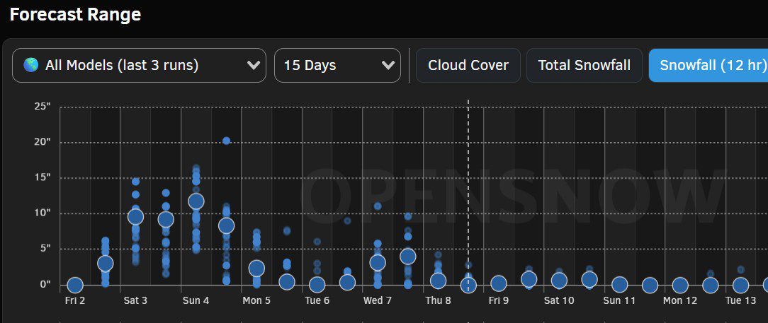
We are only expecting around 3-6 inches on the upper mountain by Saturday morning, with the additional 2-3 feet of snow expected to be on the ground fairly evenly split between Sunday morning and Monday morning. I put OpenSnow’s 12-hr increment snowfall forecast for mid-mountain up top of this post.
Monday System:
The latest trend with the Monday-Monday night system is for it to spin south down the CA coast, with most of the precipitation staying west of the Sierra. The winds come down on Monday, and it will be cold, with some snow showers around. The latest trends would only bring the mountain a final 1-3 inches of snow.
Tuesday – Thursday:
To round out the 7-day forecast period, we have a dry day for Tuesday with mostly sunny skies expected. Highs in the 30s for the lower elevations, and 20s for the higher elevations.
A final weak system is forecast to move through sometime on Wednesday into Wednesday night, with a few lingering snow showers possible into Thursday before the storm clears out. This storm could bring a final round of snow measured in inches, not feet, before we shift into a drier pattern beyond the 8th.
Long-Range Outlook:
By the 9th through mid-month, we shift back towards a -EPO pattern with the high-pressure ridge building over the West Coast. That will bring us a drier pattern, but it is forecast to stay fairly cold. Near mid-mountain, ~7500′, the OpenSnow forecast shows high temperatures near or below freezing over the next two weeks.
We will have a decent snowpack and base on the mountain after the storms this week, so with the cold air sticking around, a drier pattern won’t be an issue, and it will be an opportunity for some nice sunny skiing days.
Of interest is that the longer-range ensemble mean models continue to show the ridge slowly retrograding NW towards the Gulf of Alaska beyond mid-month. If that continues westward towards the Aleutian Islands later in the month, then we could start with colder storms dropping in from the north, and eventually storms could develop off the coast again.
We’ll continue to watch the trends and hope that happens, and that we see storms return later in the month.
BA
