Skip to content
Palisades Tahoe Logo Palisades Tahoe Logo Palisades Tahoe Logo
Explore
Main Menu
  • Explore Palisades Tahoe
  • Base to Base Gondola
  • Our New Name
  • Explore Legendary Lifts
  • Palisades Tahoe Blog
  • About Lake Tahoe
  • About Us
Plan Your Visit
Main Menu
  • Tickets & Passes
  • Lodging
  • Lessons & Guides
  • Deals & Packages
  • Rentals & Demos
  • Travel Here
  • Getting Around
Mountain Information
Main Menu
  • Snow and Weather
  • Lift and Grooming Status
  • Webcams
  • Hours of Operation
  • Trail Maps
  • Parking & Road Conditions
  • Snowfall Tracker
Events & Activities
Main Menu
  • Events Calendar
  • Activities
  • Dining & Apres
  • Shopping
  • Things To Do In Lake Tahoe
  • Groups, Meetings & Weddings
  • Ski & Snowboard Teams
IKON PASS HOLDER LODGING DISCOUNT

Ikon Pass holders save up to 20% on slopeside lodging at The Village at Palisades Tahoe.

SLOPESIDE LODGING
Icon / FlashCreated with Sketch.
View All Offers
  • Weather

A Dusting Monday, Heavier Snow Possible Thursday

  • Nov 27, 2022
  • 8:42 am

Monday System:

The Monday system will bring in colder air and gusty winds. Expect some possible upper mountain lift closures as west winds gust up to 70+ mph. High temperatures drop into the 30s at the base and 20s up top.

A few snow showers are possible Monday afternoon and evening. Only expecting enough for a dusting up to an inch of snow on the mountain.

Tuesday – Wednesday:

Tuesday into Wednesday the sun returns and the winds come down for Tuesday. But it stays cold with highs in the 30s. Wednesday the winds begin to crank back up by afternoon ahead of the next storm. Southwest winds gusting up to 50+ mph over the ridges.
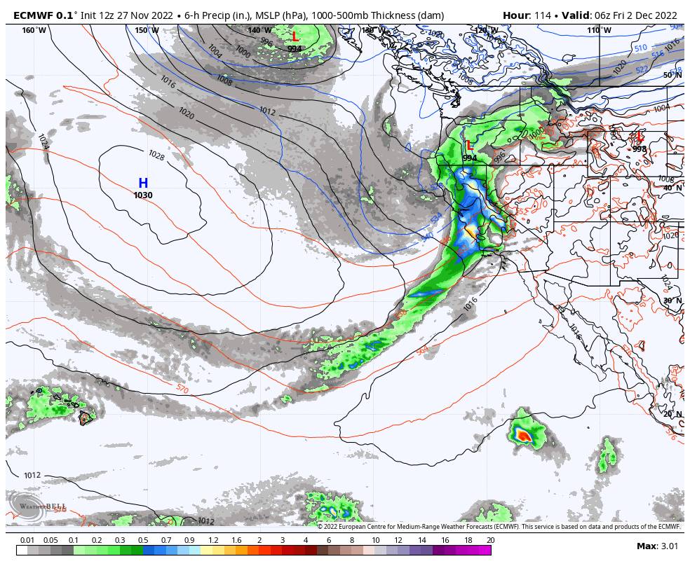
Thursday Storm:

The next storm is still on track to dig south into CA Thursday. The latest model runs continue to show the system tapping into moisture off of the Pacific with a weak AR (atmospheric river) pointed at the Sierra Thursday afternoon-evening. The limiting factor with this storm could be the fast movement of the moisture feed from north to south through CA.

Winds crank up to over 100 mph over the ridgetops Thursday so expect some lift closures. The moisture is forecast to reach the Tahoe Basin around late morning and continue through Thursday night, then clearing Friday. Snow levels may start out just below the base and fall below 4000 ft. Thursday night.

That means this storm could start with thicker snow Thursday that turns more powdery with the snow showers behind the moisture stream Thursday night. The latest model runs show enough precipitation for around 1-2 feet of new snow on the mountain with this storm if the current model trends continue.

The storm is forecast to wind down by late morning Friday with clearing Friday afternoon. The winds should come down some Friday morning as well for a good powder day.

Long-Range:

Another storm is still on track to move in by Saturday night into next Sunday the 4th. This system could also tap additional moisture off of the Pacific. Currently, the amounts look to be less than the Thursday storm, but it could still be another decent shot of new snow. We’ll continue to track it all week.

The long-range models suggest that troughing could be over CA more than not over the next 2+ weeks, so the pattern may remain fairly active.

BA

lake tahoe weather palisades tahoe weather forecast snowfall forecast
Bryan Allegretto
Bryan Allegretto

Share this article:

Recent Posts

  • Weather ·
  • February 8, 2023·

Tracking Light Snow for Friday Night

Wednesday – Thursday: Mostly sunny skies through Thursday. Highs into the 30s for the upper mountain and 40s at the…
Read more
  • Weather ·
  • February 7, 2023·

Weak System Possible Fri Night – Saturday

Tuesday – Thursday: Mostly sunny skies with a few clouds possible through Thursday as high pressure builds in over CA.…
Read more
  • Weather ·
  • February 6, 2023·

1-2 Feet of Fresh Snow

Snowfall Report: We definitely saw more than the 8 inches being reported by mountain ops fall on the mountain on…
Read more

Social

Instagram Twitter Facebook Youtube

Contact

   Email Us
   1.800.403.0206

Our Partners

U.S. Forest Service Logo
1960 Olympic Valley Road
Olympic Valley, CA 96146

©2022 Palisades Tahoe

Alterra Mountain Company
  • Privacy Policy
  • Terms of Service
  • Photo Upload Terms of Use
  • Accessibility
  • Do Not Sell My Personal Information
  • Privacy Policy
  • Terms of Service
  • Photo Upload Terms of Use
  • Accessibility
  • Do Not Sell My Personal Information