National Weather Service Forecast
Flood Warning updated as of January 8, 2017 at 3:12pm: “An atmospheric river is producing intense rainfall with snow levels near 9000 feet. Intense rain, saturated soils and melting snow are producing widespread flood impacts. Rain and snow levels will decrease tonight, however flood impacts will continue into Tuesday… Stay home unless you are directed to evacuate by emergency management. Travel is strongly discouraged! If you must travel, attempt to return before sunset. The dangers of flooding are much more difficult to spot at night. Never drive through flooded areas.” – NOAA Weather Warning
Please stay safe!
National Weather Service Winter Storm Warning
Winter Storm Warning updated as of January 8, 2017 at 2:54pm: “Winter storm warning in effect from 4am Monday to 4am PST Thursday…
*Timing: Heavy Rain will transition to snow Monday morning with periods of heavy snow continuing through Wednesday night.
*Snow Accumulations: 4 to 8 feet about 7000 feet with 1 to 3 feet at Lake Tahoe Level.
*Winds: Southwest 15 to 25 mph with gusts 45mph. Sierra Ridge gusts over 100 mph.
*Snow levels: All Valley Floors…Briefly rising to around 6500 feet Tuesday night before falling again.
*Impacts: Dangerous conditions will exist for travel and outdoor activities with heavy snow accumulation on all Sierra Passes. The combination of heavy snow and gusty wind may make for whiteout conditions.” – NOAA Winter Storm Warning

Operations Update for Monday, January 9, 2017
Squaw Valley and Alpine Meadows, as well as all other Lake Tahoe ski resorts, were closed today, January 8, due to severe weather that included heavy rainfall, extremely high winds, and lightning. Winds sustained 100mph on the ridge today with gusts peaking up to 175mph. These conditions kept us from traveling to the majority of our mountain facilities and terrain today, and therefore we have been unable to access and repair possible damage caused by these servere conditions. Based on the forecast for sustained winds and heavy snowfall starting overnight, Palisades Tahoe will remain closed on Monday, January 9.
Operations Update for Tuesday, Janury 10 and beyond….
Sunday’s heavy rain followed by the incoming heavy snowfall will likely cause delays over the next few days as we work to repair any damage that happened on the mountain and in the base area. Severe weather and high winds will impact our operations, and our teams will be out there working hard to open terrain for skiing and riding while at the same time making sure that our terrain is safe for our guests. We appreciate you being patient as we are working hard to return to normal operations.
Feet of snow this week
Updated by Resident Weather Blogger BA on January 8, 2017 at 8:39am…
Snow levels fall overnight to 8000 feet around 10 pm, 7000 feet around 1 am, and to the base by morning.
We could see 6-12 inches on the mountains overnight. Monday into Monday night snow levels are below lake level as the snow continues. By Tuesday morning we could have an additional 8-16 inches at the base, and 16-23 inches on the mountain.
The snow continues Tuesday through Thursday as more waves move through. Over the 3 day period we could see an additional 2-3 feet of snow at the base, and 3-4+ feet for the mountain by Friday morning.
BA
Operations Update for January 8, 2017
Squaw Valley and Alpine Meadows are be closed for skiing and riding on January 8, 2017 due to weather and conditions. Please note that all ski school programming, teams, SnoVenture activities and the Squaw Alpine Express will also not operate. On days like this, it is best to stay tuned to the app and website for real-time resort information.
National Weather Service Forecast Update
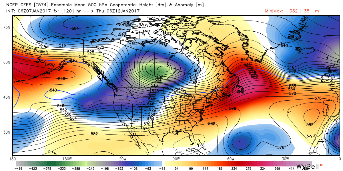
UPDATED as of January 7, 2017 at 3:34am: “Snow with possible freezing rain today will transition to heavy rain and heavy mountain snow in most areas tonight, with extreme amounts of rain Sunday through early Monday. Significant flooding is expected for mainstem rivers, creeks, and streams Sunday into Monday. Another atmospheric river event is looking likely for the middle of next week with a couple of colder storms to follow the end of next week.” – NOAA Weather Discussion

Operations Update for January 7, 2017
Heavy rains and high winds are significantly impacting our operations today, and our teams are out there working hard to keep terrain open for skiing and riding while at the same time making sure that our terrain is safe for our guests. While today and tomorrow will bring very challenging weather, we are looking at significant snowfall beginning again on Monday through next week—we’re looking at several feet of snow!
Check out the winds at the top of Alpine Meadows and Squaw Valley…


Operations Update for January 9, Monday and beyond…
Sunday’s heavy rain and severe weather will likely cause delays over the next few days as we work to repair any damage that happens on the mountain and in the base area. Severe weather and high winds could impact our operations, and our teams are out there working hard to keep terrain open for skiing and riding while at the same time making sure that our terrain is safe for our guests. We appreciate you being patient as we are working hard to return to normal operations.
Colder Storms This Week
Updated by Resident Weather Blogger BA on January 7, 2017 at 7:33am
No break as another significant storm moves in Tuesday into Wednesday. This one is colder and could bring 1-2 feet at the base, and 2-3 feet to the mountain by Wednesday night. Snow levels may rise to near the base briefly Tuesday night before falling again.
Another storm may move through Thursday into Friday. This storm looks like it could track to our South making it colder and lighter for us. Rough estimate 5 days out is around a foot of snow on the mountain possible.
So Monday through Friday we could see 4-7 feet on the mountain after the rain storm this weekend, similar to the amounts of snow we saw this past week. We may see a break in the storms the weekend of the 14th into the first part of the week of the 16th. Then later that week we may see a pattern setup that could bring some colder storms.
BA
JANU-Buried 2017 Fact
2017 is off to a record start: We are already well ahead of our average January snowfall and are on track to break our 45 year historic record of 175 inches of snow in January (in 1981-82!). These storms are setting us up, yet again, for Tahoe’s longest season.

