Palisades Tahoe Logo Palisades Tahoe Logo Palisades Tahoe Logo
Explore
  • Explore Palisades Tahoe
  • Our New Name
  • Explore Legendary Lifts
  • Palisades Tahoe Blog
  • About Lake Tahoe
  • About Us
Plan Your Visit
  • Tickets & Passes
  • Lodging
  • Lessons & Guides
  • Deals & Packages
  • Rentals & Demos
  • Travel Here
  • Getting Around
Mountain Information
  • Snow and Weather
  • Lift and Grooming Status
  • Webcams
  • Hours of Operation
  • Trail Maps
  • Parking & Road Conditions
  • Snowfall Tracker
Events & Activities
  • Events Calendar
  • Activities
  • Dining & Apres
  • Shopping
  • Things To Do In Lake Tahoe
  • Groups, Meetings & Weddings
  • Ski & Snowboard Teams
IKON PASS HOLDER LODGING DISCOUNT

Ikon Pass holders save up to 25% on slopeside lodging at The Village at Palisades Tahoe.

SLOPESIDE LODGING
Icon / FlashCreated with Sketch.
View All Offers
  • Operations

Operations Update: February 6

  • Feb 5, 2017
  • 4:30 pm

Today’s Overview: February 5, 2017

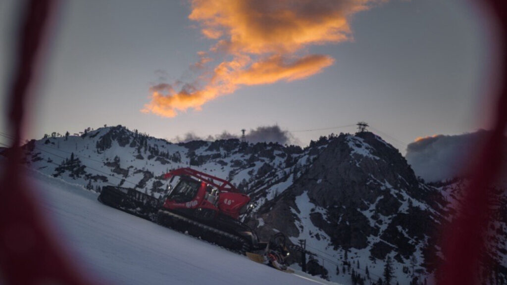
Today we saw windy weather in front of the incoming storm. Fortunately, the winds were not quite as high as anticipated and both Squaw Valley and Alpine Meadows were able to open some upper mountain lifts for most of the day. Blue skies peaked out and fun turns were made!

Top of Summit at 3pm today taken from our 360° Roundshot cam

Photo: Top of Broken Arrow at 1:30pm

Incoming Storm Cycle

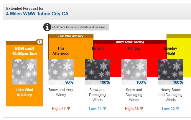
We have an active week of weather ahead. The National Weather Service has issued a Winter Storm Warning in effect from 10pm this evening until 10pm Monday. Here is a storm cycle update from BA as of 7:28am:

Storm #1

Snow moves in this evening and continues through the day Monday.  Snow levels look to hover right around the base.  With the lighter precip we could see rain mix in down low.  Winds increase Monday with mountain top gusts to 100+ mph. We could see 6-9 inches at the base by Monday evening, and 7-13 inches on the mountain.

Storm #2

Another change this morning is that the atmospheric river taking aim at Northern CA behind this storm is speeding up.  So the heavy precip looks to move in right in its heels Monday evening.  This will bring heavy snow Monday evening but also snow levels rise sooner.  We should start as heavy snow down to near the base during the evening and then rise to 7000 feet by 10 p.m. and 8000 feet by 4am Tuesday. We could see 4-7 inches at the base Monday evening before the switch to rain, and 9-18 inches on the mountain by Tuesday morning. 

Tuesday the heavy precip continues with snow levels continuing to rise.  They may hit 9000 feet by Tuesday afternoon.  Winds still gusting up high over 90 mph.  We could see 7-11 inches of wet snow above 8000 feet Tuesday morning before a change to rain up to 9000 feet. The good news is that the GFS and European models have both trended towards the heavy precip ending Tuesday night.  We may only see light rain showers Tuesday night through Thursday with a break possible in the precip.

Storm #3

Thursday night an approaching cold front pushes the AR back into the area with heavy precip returning.  As the front pushes closer Thursday night snow levels begin to fall.  They should start above 8000 feet Thursday evening by then fall steadily overnight and to near the base by Friday morning.  Winds should be strong again Thursday into Thursday night. We could see 5-8 inches on the mountain Thursday night above 7000 feet. 

Friday the GFS forecast model moves the storm out pretty fast.  The European model brings another wave behind the front and keeps snow showers going Friday before tapering off Friday night.  We could see a few more inches if the snow showers continue.

Tomorrow’s Operations Outlook, February 6, 2017

Source: NOAA Forecast


We expect that the forecasted snow accompanied by “damaging winds” will affect tomorrow’s lift operations. Wind gusts along the ridge are forecasted in excess of 100mph. Wind holds are likely for the upper mountain lifts, so please check our lift & trail status page and app for updates tomorrow morning and throughout the day.


admin
admin

Share this article:

Recent Posts

  • Operations ·
  • May 26, 2022·
A Snowcat farms snow to keep trails covered

Operations Update: Weather Expected for Closing Weekend

last weekend of winter operations for the 2021-22 season. We have some weather moving in that could impact lifts on Friday and Saturday, but Sunday and Monday should be clearer days overall. The final day to ski or snowboard will be Monday, May 30th. Resort hours of operations will still be 8am-2:30pm.
Read more
  • Operations ·
  • May 19, 2022·
Skier in Spring off Siberia at Palisades Tahoe

Operations Update: Lifts Opening Earlier This Weekend

We are officially shifting our hours of operation this weekend to make the most of Spring conditions and getting the…
Read more
  • Operations ·
  • May 12, 2022·
Groomed runs are the place to be in the Spring.

Operations Update: Warm Temps Return; Granite Chief Closed

After a small but exciting refresh of snow this week, we will be opening again on Friday, Saturday, and Sunday for skiing and snowboarding. It will feel like spring out there, so get those boards and skis waxed, and come in costume: This weekend is Rodeo-themed. Our hours are still 9am-4pm, though that could change as soon as next week.
Read more

Social

Instagram Twitter Facebook Youtube

Contact

   Email Us
   1.800.403.0206

Our Partners

U.S. Forest Service Logo
1960 Squaw Valley Road
Olympic Valley, CA 96146

©2022 Palisades Tahoe

Alterra Mountain Company
  • Privacy Policy
  • Terms of Service
  • Photo Upload Terms of Use
  • Accessibility
Menu
  • Privacy Policy
  • Terms of Service
  • Photo Upload Terms of Use
  • Accessibility