With the so called “Miracle March” now in the rearview mirror delivering a big ole goose egg in the snowfall department, powder days had started to slip from our minds. We embraced the shift, spring skiing was here, and the corn harvest was in full effect.
Then last week happened. A surprise refresh rolled through and delivered one of those bluebird powder days that reminds you why you keep checking the forecast in the first place.
And if you’ve been watching the weather lately… you already know. Winter isn’t quite done with us yet. Snow is back in the forecast, and this weekend has the potential to bring another solid refresh to the mountain. It may have taken a while to get back here, but at this point, we’ll take every inch we can get.
Of course, with spring storms comes a little bit of everything.
We’ll likely have to eat some rain first before things turn over to snow. As temperatures drop, precipitation turns form rain to snow, and that transition will also bring increasing winds and potential lightning, especially across the upper mountain. Those elements can create unsafe conditions quickly, and our teams will be monitoring things closely throughout the day and adjusting operations as needed to keep everyone safe.
If we stay patient and let this storm cycle play out, there’s a chance we’re looking at another fun reset heading into Sunday and Monday. If this season has taught us anything, it’s that things can change quickly. One day you’re out there in a t-shirt and sunnies, lapping corn under bluebird skies… and the next you’re throwing on base layers, chasing fresh snow.
Classic Sierra. How can you not love this place?
Weather & Conditions
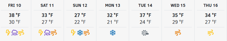
Showers Rolling Through Friday & Saturday
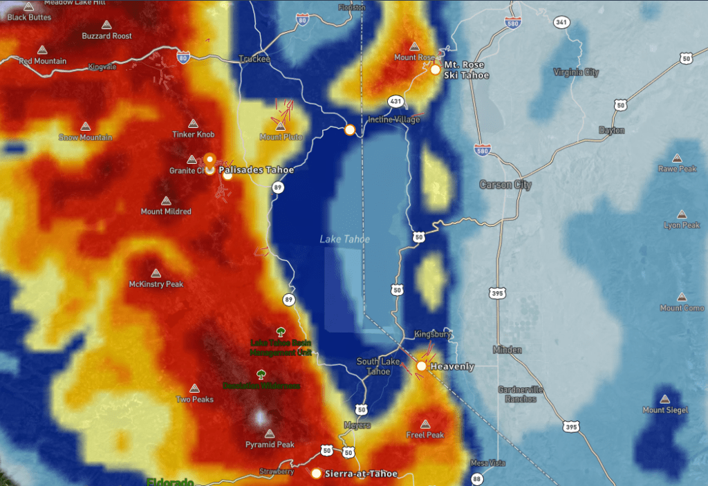
We’re in a classic spring storm pattern with on-and-off rain and snow showers moving through Friday into Saturday.
Snow levels have been hovering on the higher side, meaning:
- Rain at the base at times
- Wet snow up high, with a few inches possible on the upper mountain
Winds will also be on the rise Saturday, with ridgetop gusts picking up into the 40-50+ mph range, which could impact lift operations throughout the day.
Saturday Night Into Sunday: A Colder Refresh
Here’s where things get a bit more interesting.
A colder system moves in Saturday night, dropping snow levels quickly down to the base and bringing a more winter-like feel back to the mountain.
Current expectations:
- Snow levels dropping to the base Saturday night
- Steady snow into Sunday
- 6-11 inches possible near the base
- 13-18 inches around mid-mountain
- Up to 20+ inches up top
Most of this snow is expected to fall overnight into Sunday morning.
A Spring Curveball
As with many spring storms, this one comes with a little extra energy.
We could see convective bursts of snow, thunder, and even lightning at times, which can create rapidly changing conditions across the mountain.
Looking Ahead
Conditions begin to settle early next week with:
- Partly to mostly sunny skies Monday through Wednesday
- Cooler temps sticking around to help preserve the new snow
Another weak system could brush through midweek, but overall, we’re looking at a more stable stretch after this weekend’s storm cycle.
A little rain, a little wind, and then a solid shot of snow to close out the weekend.
Not the cleanest storm from start to finish, but if everything lines up, Sunday could bring a pretty fun reset across the mountain.
With thundersnow in the forecast, it might be a tough watch for skiers and riders, but you already know Jim Cantore is absolutely fired up about it. Once this storm cycle moves through, conditions are lining up to be well worth the wait, so stay patient and embrace the chaos.
For a deeper dive into the forecast and long-range trends, visit our Weather Blogs, written by Bryan Allegretto of OpenSnow.
Lift & Terrain Operations
Weather Impacts & Weekend Operations
This weekend’s incoming weather will likely have a direct impact on lift and terrain operations, especially on Saturday.
With Mountain Run currently closed, lightning protocols are especially important. When lightning is detected in the area, we must clear the mountain and download all guests via the Funitel, as skiing down is not an option. Please keep this in mind and plan to head in early if conditions begin to shift.
Friday (4/10):
Due to continued lightning strikes in the area, the mountain is now closed for the remainder of the day.
We appreciate everyone’s understanding as our teams continue to monitor conditions closely.
Saturday (4/11):
There is a possibility of an initial opening in the morning, but conditions are expected to deteriorate throughout the day. Increasing winds and the potential for lightning in the area may create an unsafe operating environment on the upper mountain.
Guests should be prepared for:
- Potential delayed openings
- Early closures
- Lift holds or wind-related shutdowns
If you’re planning to get out on Saturday, the best strategy is to get out early and stay flexible.
Sunday (4/12):
Conditions look more favorable for operations, but weather may still impact the start of the day.
Overnight snowfall will require time for:
- Avalanche mitigation
- Lift preparation
- Terrain assessments
Because of this, guests should expect:
- Possible delayed openings Sunday morning
- Wind holds or intermittent lift delays throughout the day
Around-the-Clock Effort
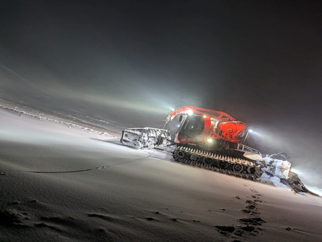
As always, our Mountain Operations and Ski Patrol teams will be working hard behind the scenes to open terrain as quickly and efficiently as possible without compromising safety.
With overnight snowfall expected, our mountain operations teams will be working throughout the night on the upper mountain, putting in long hours to ensure everything is as ready as possible for the day ahead.
Every decision made throughout the weekend will be based on real-time conditions, and operations may change throughout the day.
Terrain Parks Update
Gold Coast Park recently added a new jump line, and park crew has set out the spring challenge rail which features four pipes in a row, creating one seriously long rail.
With new snow on the way, park features may take a bit of time to reset and shape, but once crews work through the refresh, expect both Gold Coast and Belmont to be back in prime form and ready to rip.
Season Outlook
We know many of you are wondering about a closing date, and we appreciate the patience as we navigate a season that’s required a lot of flexibility.
At this time, we’re feeling confident in lift operations into the second half of April, and we’ll reassess after this weekend’s snowfall to determine if there’s potential to extend beyond that.
Our mountain operations teams are doing everything possible behind the scenes from moving snow to making strategic decisions all with the goal of keeping us sliding on snow for as long as conditions allow.
Lift and terrain status may change throughout the day. For the most up-to-date information, please check the Ikon Pass App or the Mountain Report before and during your visit.
Safety First, Always
Conditions across the mountain continue to evolve, especially with this incoming storm cycle and dropping temperatures. As temps cool and new snow moves in, surfaces may firm up quickly, creating a mix of conditions throughout the day.
Natural hazards still exist across the mountain. Rocks, stumps, and uneven terrain may be just below the surface, especially in off-piste areas where coverage can vary. Please ski and ride in control, stay aware of your surroundings, and choose terrain that matches your ability level.
With new snow on the way, now is also a great time to brush up on your snow safety knowledge before heading out:
Events & Activities
This time of year continues to deliver some of the most electric energy of the season.
From live music and après scenes to marquee competitions and community gatherings, spring at the Spring Skiing Capital® is in full swing. Big names, big crowds, and that unmistakable spring vibe.
This weekend keeps the momentum rolling with Spring Tracks returning for round two, featuring Marc Montoya and Valentino Khan bringing the heat to the KT Deck.
Rahlves Banzai Tour (April 10–12)
The Rahlves Banzai Tour returns to Palisades Tahoe, combining big mountain freeride terrain with the head-to-head intensity of ski and snowboard cross. Expect high-speed, no-holds-barred racing as competitors charge down natural terrain in four-person heats.
And this year? It’s lining up with a little bit of everything from Mother Nature.
Dynamic weather, changing conditions… honestly, that’s part of the Banzai spirit. This event has always been about adapting, sending it, and embracing whatever the mountain throws your way.
The weekend kicks off with the Banzai Welcome Party tonight (4/10) at EVO Sierra Surf Club in Tahoe City, setting the tone for a full weekend of competition, community, and chaos in the best way possible.
Whether you’re competing or just watching from the sidelines, this is one you won’t want to miss.
Transportation & Parking
All parking is now first come, first served, so we recommend arriving early to lock in a good spot and get your day started on the right foot.
Alternate Transportation Options
Looking to skip the parking shuffle? There are still plenty of convenient ways to get to the mountain:
- TART service is available from Truckee and Tahoe City
- Resort transportation, including the Mountaineer, is available for guests staying in Olympic Valley and Alpine Meadows
Shred the Storm
This weekend might take a little patience. A little rain, some wind, a few curveballs… and then, if everything lines up, a fresh layer of snow waiting on the other side.
Between the potential for a Sunday reset, the return of the Rahlves Banzai Tour, and the continued push from our mountain operations teams to keep things spinning, there’s still plenty of good times ahead.
It may not always be perfect. It may not always go according to plan. But if you’re willing to roll with it, stay flexible, and embrace a little chaos… this could end up being one of those weekends you’re really glad you showed up for.
We’ll see you out there.