Snowfall Report:
An additional 6 inches of snow fell from Monday into Monday night on the mountain. That brings the storm total to 16 inches, which is more than we expected from the storm. It also brings the total for the week to 26 inches!
All of the new snow caused the management team to move the opening day up to this Saturday, the 21st!
Tuesday:
We have a break between storms on Tuesday with partly-mostly sunny skies. Highs in the 30s for the lower elevations and 20s for the higher elevations.
Wednesday – Thursday Storm:
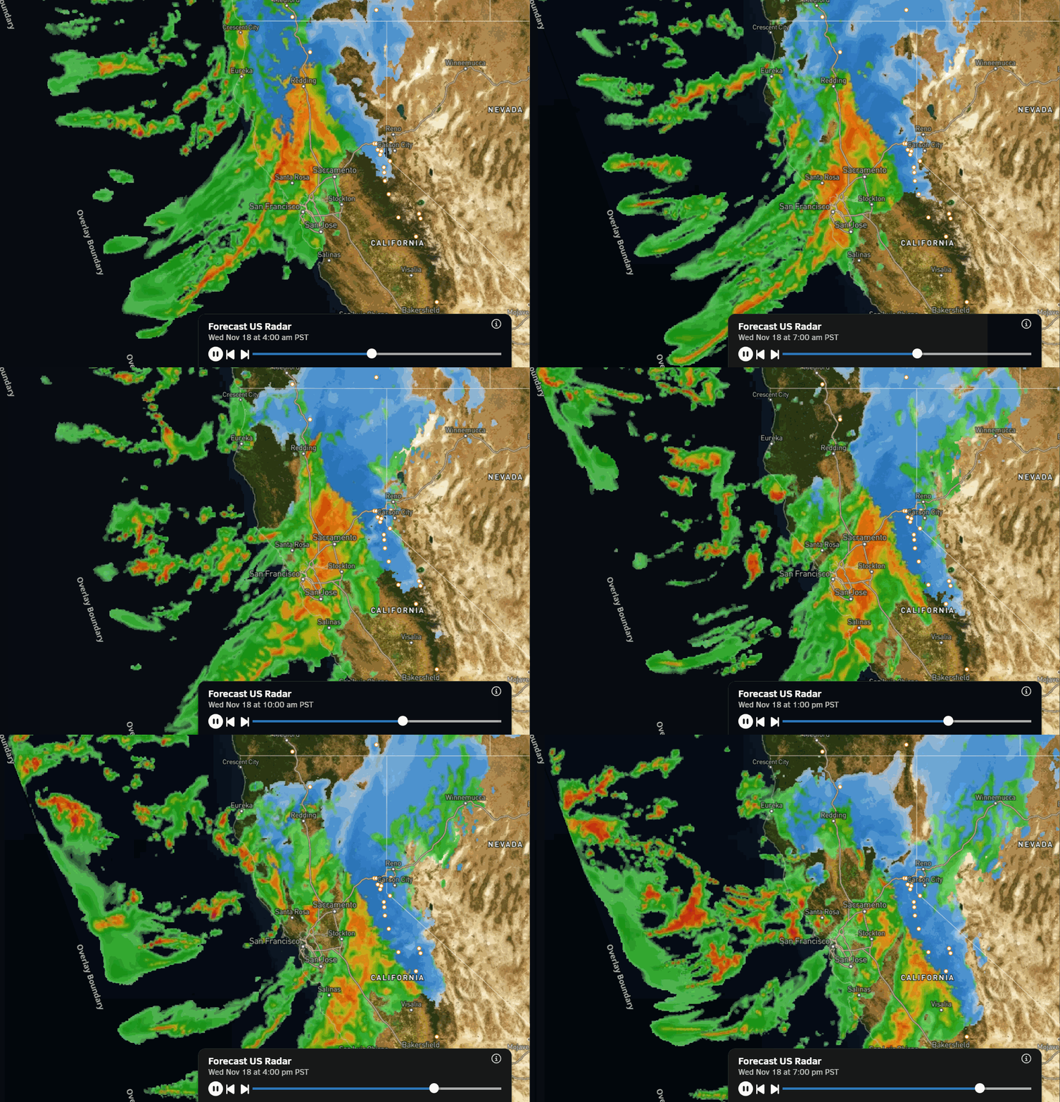
The initial band of snow is forecast to push into the northern Sierra Wednesday morning, with heavy snow into Wednesday night. The center of the low-pressure system moves directly through the Sierra on Thursday, keeping the snow going. The snow will lighten Thursday night and then taper off by Friday morning.
Highs only in the 20s on the mountain, up to near freezing at the base. Ridgetop winds gusting up to 70-80+ mph, creating blowing snow and low visibility on Wednesday, and then diminishing on Thursday.
The latest model runs have been increasing the precipitation forecasts. The bigger story than the total precipitation amounts is the cold nature of the storm, with snow levels sitting around 2000 ft. below the base. That will bring us all snow and high snow ratios fluffing up the snowfall totals!
The 2-day snowfall totals by Friday morning could be around 2.5 – 3.5 feet near the base, and 3.5 – 4.5 feet on the mountain. That’s on top of the 2+ feet already seen this week. Over 5 feet of snow during the 3rd week of November? That’s a great start and maybe the best since 2010!
Friday – Saturday Weather:
We expect another break in the storms Friday into Saturday, with partly-mostly sunny skies and cold temperatures. Highs in the 20s for the higher elevations and 30s near the base. The winds will increase on Saturday ahead of the next storm, with ridgetop gusts from the SW up to 50-60+ mph by afternoon. So watch for that if you plan to ski opening day.
Saturday Night – Sunday Storm:
A weakening storm will push through the region Saturday night into Sunday. We are expecting much less precipitation, but it could be the icing on the cake to a great week of snowfall. We could see snow showers by evening that last into the day on Sunday, and diminish by Sunday evening. Still cold, with highs in the 20s on the mountain and 30s near the base.
The snow levels should be around 2000 ft. below the base again. This system is nothing to sneeze at if the model average verifies, as we could add an additional 3-7 inches of snow at the base, and 5-11 inches on the mountain.
By Monday morning, we’ll hopefully be taking a break again and taking a breath after quite the 10-day snowstorm cycle. But it may not last long…
Long-Range Outlook:
The long-range models show the eastern Pacific trough near the West Coast next week through the end of the month, but they have trended it a bit farther west again. They still show it just close enough to keep the door open to storms reaching the northern Sierra.
The latest operational model runs show more storms between next Tuesday and the end of next week, and some through the end of the month. As of now, we expect the active pattern to continue through the last week of November.
But as we get closer to the end of the month, if the trend is for the trough to pull westward a bit, that could diminish the storms or their strength. It could also make them a bit milder, with more marginal snow levels next week.
I’ll continue to watch the trends in the long-range. Any slowdown in storms is expected to be short-lived, as we expect another active storm pattern in December, and likely through the heart of the winter with this strong El Niño pattern.
BA