

Usually, as forecasters, we try not to look at a specific forecast model’s forecast, as it could be way off. We look at multi-model trends as storms get closer. The trend is your friend when making forecasts, but not when those trends are drier and milder, and you are a skier waiting for snow…
Mild Weekend:
The partly-mostly sunny skies will continue with highs into the 60s and 50s for the upper mountain. Then cooling into the 50s and 40s on Monday, with ridgetop winds increasing to 50-60+ mph by afternoon.
Weakening Storms:
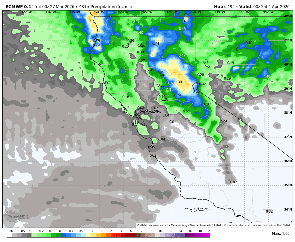
The European model was the first yesterday to catch onto the first storm falling apart and not bringing in steady precipitation on Tuesday into Wednesday. That trend continues today with barely any precipitation forecast through Wednesday afternoon now, and the GFS model is trending towards the European model solutions.
Interestingly, several of the other forecast models still show steady precipitation reaching the northern Sierra with the first system on Tuesday into Wednesday. We’ll have to see if more jump on board with the Euro and GFS; my guess would be yes.
The drier solutions are also warmer, with snow levels up above 8000 ft. on Tuesday, and maybe dropping near 7000-7500 ft. on Wednesday with any showers. The wind forecasts are also lighter with 30-40+ mph ridgetop gusts on Tuesday, but then 60-70+ mph by Wednesday afternoon. Highs in the 40s for the lower elevations and 30s on the upper mountain.
Wednesday Night – Thursday Storm:
The next storm moves through from the NW Wednesday night into Thursday. The European model was trending this storm’s track farther north yesterday, and continues that trend today. The GFS model has now trended towards the European model with the 2nd storm as well.
These scenarios would only bring us clouds and lighter rain/snow showers each day, and maybe a small window of steady snow Wednesday night into Thursday morning, with a high-end of 6-9 inches of snow in total above 8k’ by Thursday afternoon.
There are several other models that are not only wetter Tue – Wed, but also still farther south with the track of the Wednesday night – Thursday storm. The National Blend of Models forecast model is still showing up to 1.5 inches of total precipitation, and 12-18 inches of snow on the upper mountain.
The snow levels on the drier model solutions only drop to around 7000 ft. Wednesday evening, and 6000-6500 ft. by Thursday morning, before rising back up near 7000 ft. by afternoon with any lingering showers as the storm clears the region. The wetter models would have lower snow levels.
We will see colder air, which will slow the melting. Highs only in the 30s on Thursday, down to the base. Ridgetop winds are strong Thursday morning but falling through the day. Now that the storms are getting within 5-6 day window, I’ll start to make a snowfall forecast based on the latest model averages.
We could see 0-3 inches near the base, 5-9 inches near mid-mountain, and 7-12 inches up top by Thursday afternoon. Most of that could fall on Wednesday night into Thursday morning. If the wetter models are right, we could see more; if the drier models are right, we could see less. Drier is the trend right now.
Beyond the 2nd:
Next Friday, April 3rd, should still be on the colder side behind the cold storm moving through. Highs in the 30s to near 40 degrees down near the base, along with lighter winds.
High pressure builds in near the West Coast by the first weekend in April, and is forecast to stay there into the 2nd week of the month. That will block storms and bring back a drier weather pattern.
If the mean ridge center stays off the coast, that should keep temperatures seasonal, with highs in the 50s for the lower elevations and 40s for the upper elevations. There is a chance a system drops in from the north with enough moisture for after showers to pop up with daytime heating, but that chance looks small.
Long-Range Outlook:
The longer-range models suggest that the ridge could back west by mid-April. That could bring in some cooler air and open the door to storms having a better chance of dropping in. But it’s mid-April with a weak and shifting north jet stream, so bigger storms are unlikely. A better chance for showers with any system.
BA
