

Winding Down the Mild Pattern:
We continue to watch the trends for the two potential storms for next week as we continue to ride out this record dry and mild period, which finally ends on Monday. Highs into the 60s near the base and 50s up on the mountain through the weekend, and around 10 degrees cooler for Monday.
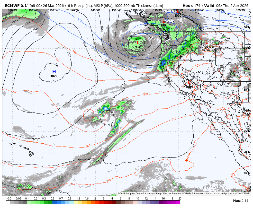
The Latest Snowstorm Trends:
The last couple of days, the models were trending wetter, they reversed over the past 24 hours and are trending a bit drier, with the European model trending a lot drier. Let’s compare the latest European and GFS operational model runs.
The European model now shows the first system weakening with just lighter showers moving in Tuesday afternoon into Wednesday. The latest GFS model run still shows the original scenario with showers pushing in Monday night, and steadier precipitation for Tuesday into Wednesday.
Then, with the 2nd colder storm dropping in from the northwest Wednesday night into Thursday, the European model is not digging it as far south into CA on the latest run. The GFS model is still farther south with a wetter and colder scenario.
Most of the latest forecast model runs lean towards the wetter GFS scenario, which is good, but the European has shown this drier trend for a couple of runs now. Yesterday, the European model was one of the wettest with up to 4+ inches of precipitation, and today, it only has up to 1.4 inches. The GFS and other models still show 2-3+ inches.
The wetter and farther south scenarios would also be colder scenarios as well. Snow levels could be around 6000-6500 ft. on Tuesday into Wednesday and fall below 5000 ft. by Thursday. The European model would have snow levels above 7000 ft. on Tuesday, near on Wednesday, and don’t drop snow levels below the base until Thursday.
The drier and warmer trends on some models are shifting the snowfall forecasts down for the lower half of the mountain. We may end up with only inches instead of feet for the lower elevations. For the upper mountain, the Euro would bring up to a foot of snow while the GFS would bring up to 3 feet, so still 1-3 feet is possible, but the trend is lower.
Ridgetop winds will be gusting up to 50-60+ mph from the SW Tuesday through Wednesday before dropping through the day on Thursday. We’ll continue to watch the trends through the weekend. Cold and snow still on the way? Yes. Can we still not trust the snowfall forecasts, as I’ve been saying all week? Yes.
Long-Range Outlook:
The long-range models continue to show the trough lifting NE beyond Thursday, and a high-pressure ridge building in the Pacific near the West Coast into the 2nd week of April.
The trend is for the ridge to be a bit closer, lessening the chances for dry systems to bring enough moisture for afternoon showers during the period. We look to be going back into a drier pattern, possibly through the end of the ski season for most ski areas that plan to close by mid-April.
If the ridge stays off the coast, we shouldn’t see any heatwaves, but more seasonal temperatures with highs in the 50s for the lower elevations and 40s for the higher elevations. But that will feel pretty nice with a strong April sun.
BA
