

Snowfall Report:
We were expecting 1-3 inches of snow on the mountain Sunday night, by 5 AM Monday morning, and that is exactly what fell overnight. This is just the start, as the storm is just getting started early Monday morning.
Monday – Thursday Storms:
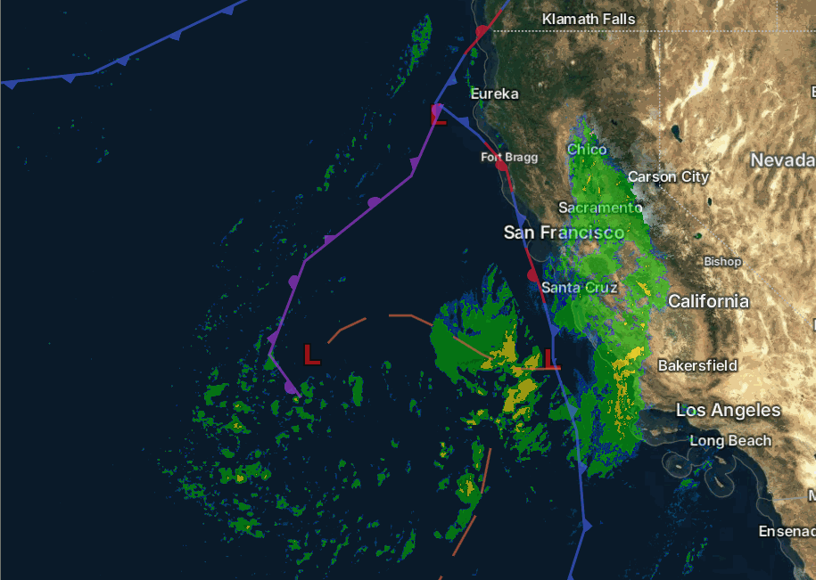
Looking at the radar as of 7 AM Monday morning, we can see that the precipitation is still sitting over the west slope of the Sierra on the east side of low pressure spinning off the coast. That will start to push east across the Sierra Monday morning into the afternoon. Highs in the 30s for the lower elevations and 20s for the higher elevations. Ridgetop winds from the SSW gusting up to 40-50+ mph.
A cold storm moves south into CA on Tuesday, continuing the snow, heavy at times, through Tuesday and into Tuesday night. Highs drop into the 20s and teens. Ridgetop winds increase to 80-90+ mph from the west, which will create low visibility, low wind chills, and likely close a lot of upper mountain lifts.
We could see snow showers on Wednesday, and then a smaller system on Thursday could bring a final round of steadier snow. Temperatures remain cold. Winds are expected to dip on Wednesday and could increase to 50-60+ mph over the ridges on Thursday with the 3rd system.
Overnight lows in the teens with single digits possible for the highest elevations. That will bring snow ratios of 15-20:1 or better Monday night – Thursday night. I will update the forecast for the remainder of the storm series each morning, but as of this morning, the latest model runs suggest that the final forecast for the storms I made on Sunday could also be the additional snowfall forecast by Friday.
That forecast was for totals of around 4-5 feet of snow near the base, 5-6 feet near mid-mountain, and up to 6-7 feet possible up top by Friday morning. Around 3-6 feet of the forecast possible by Wednesday morning, with the final foot possible Wednesday – Thursday.
Friday – Sunday Forecast:
This is the period where the forecast models are struggling the most. Some show a break Friday – Sunday with a storm digging off the coast over the weekend and pushing in Sunday night. Others suggest another small system is possible later Friday into Friday night, with the bigger storm off the coast pushing in as early as Saturday night.
We’ll continue to watch the trends. I would expect partly sunny skies with a chance of snow showers for Friday and Saturday. We’ll have to see if the next storm pushes heavier snow in by Sunday or waiting until Sunday night. Snow levels are forecast to stay below the base.
Highs warm into the 30s for the lower elevations and 20s for the higher elevations. Ridgetop winds will increase ahead of the next storm, possibly by Saturday afternoon, but Sunday could have a good chance of gusty ridgetop winds that affect ski lifts.
Another Storm Series:
The reason that some of the forecast models are now showing a chance for another small storm later Friday is that they are keeping the trough back west a bit more than previous forecasts. There is agreement that the trough digs back west off the West Coast over the weekend, but some models are faster, which is why they show the next storm by Saturday night.
Better agreement that the trough digs back south over CA by Sunday night through the middle of next week, before lifting north by the end of next week/end of February. Most forecast models show a stormy period by sometime on Sunday through the 25th/26th.
If that forecast is right, we have a chance to see at least some snow every day from today (Monday) through Wed/Thu the 25th/26th. We’ll continue to watch the trends to see if we could see snow 10-11 days in a row. That would definitely help us to come back from our seasonal snowfall deficit.
Long-Range Outlook:
By the end of the month, the long-range models continue to show the trough shifting north along with the storm track. The trend on some long-range models suggest that the trough may not lift as far north and could shift back south a bit during the 1st week of March. That could keep us on the southern edge of the storm track.
The European AI Ensemble mean model has been scoring as one of the most accurate long-range models so far this season. It suggests that the storm track shifts farther north and stays there through the 1st week of March.
We’ll continue to watch the trends to see if more storms could reach the northern Sierra beyond the storm series next week.
BA
