**5:50 PM Update on Tuesday, February 17th**
New post: Storm Cycle Update: Working Through the Storm, Towards Better Conditions
**12:15 PM Update on Tuesday, February 17th**
Due to conditions, visibility, and wind, all lifts at Palisades & Alpine are closed for the day.
**7:30 AM Update on Tuesday, February 17th**
Palisades Tahoe is implementing temporary base area closures this morning due to avalanche hazard.
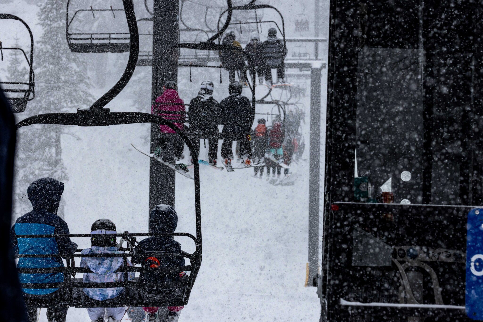
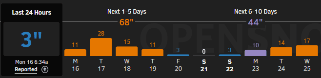
Overnight, we received 12+ inches of light-density snow at all elevations, bringing storm totals to 41 inches at 8,000′, with significantly deeper totals in wind-loaded areas. Snow continues this morning, with heavy snowfall rates expected throughout the day.
Palisades: KT East Operations
Today will follow a KT East scenario, with operations focused on lower mountain lifts east of KT-22.
- Upper mountain terrain is not expected to open under current wind forecasts.
- Guests should expect delayed and phased lift openings.
- Strong ridgetop winds (gusts into the 80+ mph range) and low visibility are impacting operations.
The Red Dog lift line will temporarily queue in the alley between Red Wolf Lodge and Palisades Kids until base area mitigation work is complete.
Alpine: Wind Holds in Effect
The following lifts will begin the day on wind hold:
- Scott
- Summit
- Lakeview
- Roundhouse
- Kangaroo
Additional lift openings at Alpine will be determined as conditions allow.
Operations will remain highly dynamic today due to heavy snowfall, strong winds, snow safety, and digging operations. Please expect changing lift status and terrain access throughout the day.
Check the Mountain Report and Ikon Pass App for real-time updates before and during your visit.
**Original Post**
The long-awaited storm cycle that began early this morning continues to intensify. Steady snowfall moved in with significant accumulation expected through Tuesday and Wednesday, setting the stage for improved conditions.
Snowfall, wind, and rapidly changing visibility will be the primary drivers of operational impacts Tuesday and Wednesday as teams work through snow safety and access challenges.
Looking ahead, clearer weather is currently forecast for Friday, Saturday, and Sunday providing a break before another potential system arrives next week. With significant new snowfall this week and improving visibility expected heading into the weekend, conditions are lining up for what could be an outstanding stretch of midwinter skiing and riding.
We’re long overdue for powder day, and our crews are working hard to move through their preparations to get lifts and terrain open. This new layer of snow is not super adhesive to the pre-storm existing snow surface, creating a less stable snowpack that requires extensive and ongoing snow safety work by our patrol and mountain operations teams. Combined with colder air moving in, strong ridgetop winds, heavy snowfall rates, and periods of low visibility, especially on Tuesday, conditions may reach blizzard-like levels.
Many lifts may begin the day in Anticipated Weather Impact (AWI) status, with openings dependent on wind, visibility, snowfall intensity, and avalanche control progress. Guests should expect delayed and phased openings, temporary lift holds, and terrain closures. Even after lifts open, changing wind speeds, snowfall intensity, and visibility may require operational adjustments as our teams continue to move at the speed of safety.
Tuesday is likely to resemble a “KT East” style scenario at Palisades, with operations focused primarily on lower mountain lifts. The Funitel is not likely under current wind forecasts, and upper mountain terrain will open only if weather and mitigation efforts allow. At Alpine, the anticipated morning lineup includes TLC, Roundhouse, Subway, Meadow, and the carpets, with additional lifts to be determined based on conditions and control work.
Deep Snow Safety Reminders:
Avalanche danger is expected to remain considerable through the week, with active mitigation work continuing across both mountains. Terrain may close at any time for control work, and rope lines and boundary markers must be respected. Our teams are moving at the speed of safety, and we ask guests to adopt that same mindset while navigating changing conditions. Expect a highly dynamic operating environment as mitigation work and weather impacts continue.
- Closed terrain is closed. Period. Give crews the space they need to complete control work, slope maintenance, and set up.
- Ride with a partner and maintain visual contact from top to bottom.
- Avoid the base of trees when skiing & riding in deep snow.
- If you are going to fall, attempt to do so feet first.
- The more snow, the higher the risk.
- We recommend you carry, and know how to use, rescue equipment, including a beacon (transceiver), shovel, probe, and whistle.
Lift Operations & The Current Scenario:
Palisades:
- Due to forecasted wind and visibility, Tuesday will likely be a “KT East” scenario, with operations focused on lower mountain lifts such as KT-22, Red Dog, Resort Chair, Far East, SnoVentures, Olympic Lady, and Exhibition.
- The Funitel is not likely to open given current wind forecasts.
- Upper mountain terrain will be prepped and ready to open if weather allows, but that is not looking likely at this time. Saddle Road has been re-established, but access to additional upper mountain terrain will remain weather dependent.
- There are no current plans to open Emigrant, Silverado, or Granite Peak during this storm cycle.
Alpine:
- Winds increased significantly this afternoon and are expected to continue impacting lift operations into Tuesday.
- The anticipated morning lineup includes TLC, Roundhouse, Subway, Meadow, and the carpets, with additional lifts to be determined based on morning assessments.
- Alpine Meadows Road may require snow safety work in the morning, which could delay access to the mountain.
What This Means for You:
Plan for changing conditions early this week, allow extra time, and be prepared for operations to evolve throughout the day and across multiple days. Strong winds and snowfall will likely limit upper mountain access through midweek.
As the storm cycle tapers and skies clear toward the weekend, terrain access and overall conditions are expected to steadily improve. Guests planning a visit for this weekend can expect fewer weather-related impacts, making it a great time to plan a day trip or weekend stay.
If you need to change or adjust your plans for existing reservations for Lift Tickets, Lodging, Lessons, Rentals, or Activities, please contact Guest Services for assistance.
We appreciate your patience as our teams work through this extended storm cycle. We are excited about the long-awaited snowfall and the conditions it will bring, and we thank you for giving our crews the time and space needed to do their work safely. Operations may change quickly based on wind, visibility, and snowfall rates. We will continue to publish Operations Updates throughout the week as needed. Please check back frequently for the latest information before heading to the mountain.