

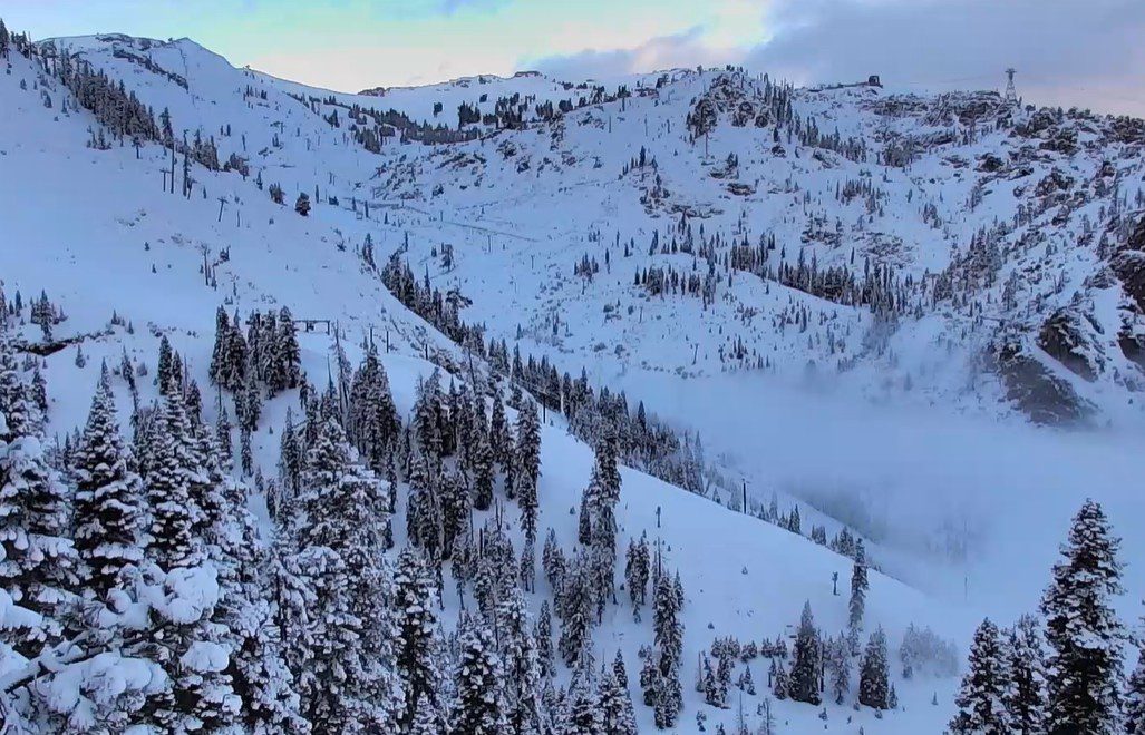
Snowfall Report:
Less than an inch fell at the base overnight Tuesday night with the mix and wet snow initially during the steadier precipitation. Up to 6 inches of snow fell overnight on the upper mountain.
We were expecting 5-10 inches up top from this storm, so we have surpassed the low end of the forecast, with a little snow still possible on Wednesday.
Wednesday – Thursday Weather:
A bit colder behind the storm with highs in the 30s both days for the lower elevations, and 20s for the higher elevations above 8000 ft. The center of the low-pressure system is still spinning near the coast on Wednesday morning as it weakens and will eventually fall apart. That will rotate additional showers into the Sierra during the day on Wednesday.
That is still a southerly flow direction, which limits orographic enhancement as it flows over the mountains, and spillover of heavier precipitation. The latest model runs show less than a tenth of an inch of additional precipitation by Wednesday evening over the mountain. That is enough for a final dusting to an inch of snow at best up top.
Wednesday night into Thursday, the flow turns northeasterly. That could bring sun and clouds for Thursday, with a chance for snow showers to pop up over the mountain from the moisture flowing in from the northeast.
Friday – Saturday Weather:
The drive up to Tahoe from the west or east for the holiday weekend will be a breeze, as we will see mostly sunny skies on Friday. Highs into the 30s for the upper elevations and 40s for the lower elevations.
Saturday, we could see some sun and clouds as the next storm starts to approach the West Coast, but digs south off the coast with dry weather expected. We could see ridgetop winds from the south increase with gusts up to 40-50+ mph during the afternoon.
Sunday – Monday Initial Storm:
As we have been discussing, the forecast is still for the first storm to dig south off the West Coast and slowly push precipitation east into the Sierra. The latest model runs show clouds for Sunday with the chance of a scattered shower by afternoon, but the steady precipitation pushing in sometime Sunday night into Monday.
The southerly flow will bring in some warmer air ahead of the initial band of heavier precipitation, and into the day on Monday, it will bring a less favorable flow for mountain-enhanced heavier precipitation, with shadowing near and east of the crest. The latest model runs show an average of 1.2 inches over the mountain by early Tuesday morning.
The snow levels will likely rise on Sunday with the southerly flow and highs in the 30s. They could start out around 6800 – 7300 ft. Sunday evening, and fall below the base by Monday morning as the snow increases, and the colder part of the pattern pushes in.
My initial snowfall forecast for possible totals by early Tuesday morning, from the first 24-36 hours of the upcoming storm series, is for around 6-11 inches at the base, 9-14 inches near mid-mountain, and 12-17 inches up top.
We’ll continue to watch the trends for Sunday into Monday to nail down the exact timing of the arrival of the first storm and the potential snowfall amounts. Each day as we get closer, I’ll add in the next day’s snowfall forecast to the forecast table as the storms get within the 5-day forecast window.
Cold Storm Series:
The well-advertised (for a month now by us) broad and cold trough pattern will settle in over the West Coast through the end of next week, and into the weekend of the 21st. That will keep the door open to several more cold storms moving through from the NW through the period.
The latest model runs show mostly continuous snowfall from the back-to-back storms through Tue-Wed, with a possible lull between storms sometime between Wed-Thu, and additional storms possible through Saturday the 21st. Snow showers could linger into the 22nd as most models start to clear out the final storm.
Showing up to 5+ inches of total precipitation falling over the mountain isn’t the most exciting part of the forecast. The cold temperatures are. The forecast above for mid-mountain temperatures is in the teens to low 20s Tuesday through Saturday.
That will bring us very low snow levels and very high snow ratios through the period, especially by Sierra standards. The snow level forecasts show hovering between 2000 – 3500 ft. through the period. Cold, moist air flowing over the mountains, and the more favorable west-east track and wind direction from Tuesday – Saturday, will all help to enhance precipitation amounts and boost snowfall totals.
Even though we can’t get into snowfall specifics with confidence for all of next week, we are pretty sure we’ll be measuring totals in feet down to the base by Sunday, the 22nd, with cold powdery snow piling up on the mountain.
The strongest winds are currently forecast for Monday into Tuesday, down some with the possible lull or smaller storms Wed – Thu, and then stronger again with the final storms Fri-Sat. If the current forecasts were to hold, that could make Wed, Thu, and Sun the best ski days of the week. Is it time to get excited? Yes, but we have a lot of details to iron out…
Long-Range Outlook:
The long-range models continue to show the storm track shifting to our north during the week of the 23rd, and even into the first week of March. That doesn’t mean that a storm doesn’t spin up that digs far enough south to bring us more snow, but the pattern of consistent and wet storms looks to be over by the 22nd.
We have a lot of powder to ski, shovel, and forecast before we have to worry about that.
BA
