

Monday – Wednesday Weather:
Mostly sunny skies through Tuesday with milder temperatures. Highs into the 40s for the lower elevations and 30s up on the mountains.
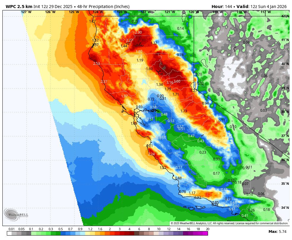
It should stay dry through Wednesday morning, and maybe into the afternoon, but then rain showers are still forecast to reach the Tahoe Basin during the evening hours. It still doesn’t look that heavy before midnight if you have outside plans, but you will likely get some rain.
Wednesday Night – Thursday Night Storm:
Steadier rain and high-elevation snow are expected to move in after midnight on Wednesday night into New Year’s Day. Then showers tapering off by Friday morning.
The snow levels will start above 9000 ft. Wednesday evening, and then drop overnight to around 8000-8500 ft. by early Thursday morning. They could hover there through Thursday with some wet snow down to 8000 ft. and rain for the lower mountains. Thursday night, as the system is tapering, they could fall slightly lower to around 7500 – 8000 ft.
That means we will see low snow ratios above 8k’ with not a lot of snow expected, especially with rain possibly mixing in near 8k’. Above 8k’, we could see 1-5 inches of wet snow by Friday morning.
This storm does not look that windy either. Still some gusty ridgetop winds from the south, but not the severe winds we can see with storms. Highs remain in the 40s for the lower elevations through Thursday and 30s on the mountain.
Friday – Saturday Storm:
There should be a lull between storms on Friday with some clouds, and the winds may start to increase from the SSW over the ridges. The next storm moves in as early as Friday evening, with the heaviest precipitation expected Friday night as the front moves through, and then showers Saturday, possibly tapering off by evening, or a few lingering into Saturday night.
The snow levels start up around 7500-8000 ft. Friday evening, and then fall to around 5500-6000 ft. (below the base) by early Saturday morning as the cold front moves through. That means rain turning to snow overnight below 7500 ft. Then hovering near to just below 6000 ft. with the lingering showers on Saturday.
The snow ratios will be low on the lower mountain with the snow levels falling halfway through the storm to the base. Above 8k, the snow starts wet and could be around 12:1 ratios by Saturday morning. Not that powdery. By Saturday night, we could see around 3-7 inches of new snow at the base, 7-12 inches near mid-mountain, and 12-17 inches up top.
First Weekend in January:
We may see another dry weekend for the first weekend in January, with highs in the 30s, and any gusty winds from the storms dropping off. It could be another beautiful weekend for skiing.
Long-Range Outlook:
The long-range models continue to show the trough staying over the West Coast through at least the 6th, with the next storm moving through around the 6th-7th. We’ll continue to keep an eye on that system as well over the next week.
Beyond the 7th, the long-range models were suggesting that high pressure could build over the West with a drier pattern developing. They now start to show that briefly around the 8th, but then another trough develops near the West Coast around 9th-10th, possibly re-opening the door to another storm.
Beyond the 10th, the long-range models are starting to suggest a -EPO (eastern Pacific oscillation) pattern setting up, with strong high pressure up near Alaska. We saw a similar pattern back in November and early December, but now we are deeper into winter with a stronger Pacific jet stream.
The long-range models are suggesting that the Pacific jet could eventually undercut the ridge to the north into CA during the 2nd week of January. This is still too far out to believe. The disrupted Polar Vortex that we’ve seen for most of this season, helping to cause a lot of lower latitude blocking patterns, has been causing the long-range models to struggle.
This outlook for possible undercutting into CA at some point during the 2nd week of January is better than the dry forecast. So we’ll continue to be optimistic and hope that we add more snow to the mountains during the 1st week of January, and that we continue to do so through the 2nd week.
BA
